by Mike Godsey, iwindsurf.com/ikitesurf.com Weatheflow.com Mail: mikeATwindsurf.com Sunday and especially Monday have wind potential with building high pressure in the Great Basin. However, coaxing the El Norte wind in the middle of the Sea of Cortez and getting the local thermal winds to jump start requires inland heating. And that, in turn, needs lots of sun. Unfortunately, the high clouds look like they will be over…
by Mike Godsey You know the routine. First one to two day of strong El Norte winds. Then 1 or 2 days of mild El Norte + mild local sea breezes. So today you would expect at least upper-teens northerly wind. But…..no. Why, let’s examine the images below. First look at the surface isobars for yesterday. Note the high pressure in the Great Basin and how…
by Mike Godsey, Mike AT iwindsurf.com The model output below from yesterday and today show 3 critical differences: 1. The high pressure is weaker today and evidenced by the greater distance between the isobars. 2. Today the high pressure has centered further north of the ideal location near the 4 corners. 3. And you can see below…
Daily Human Forecast Home | Why Baja blows | Feedback: Baja forecast | | Road Rules | Driving Down | Where to go. | | Food & Water | Camping| Resorts | Money, insurance, pets | Hurricane Diary | Windless days | East Cape driving maps | Fish/Surf | Baja photos | Forecasting for Baja’s East Cape is hard. Many of the tools we take for granted in the USA are not available. And unlike the USA where we have lots of sensors at major…
Where to go for Baja winter winds: by Mike Godsey, mikeATiwindsurf.com First, don’t confuse the April-Oct. down-the-line wave riding at Punta San Carlos and the other spots on the Baja Pacific coast with Sea of Cortez kiting and windsurfing. Different season, different crowd, and scant wave riding except when there is exceptionally big swell that breaks…
High pressure blankets mid USA creating strong pressure gradients. by Mike Godsey, mike@iwindsurf.com Tomorrow, Thursday Dec. 8, 2016 will see very strong east winds in the western Gorge to Portland while Baja’s East Cape sees significant El Norte winds. Surprisingly these winds, separated by thousands of miles of land, have the same cause. But first…
Baja Forecast and Guide Links: Home | Daily Human Forecast | Why Baja blows | Feedback: Baja forecast | | Road Rules | Driving Down | Where to go. | | Food & Water | Camping| Resorts | Money, insurance, pets | Hurricane Diary | Windless days | East Cape driving maps | Fish/Surf | Baja photos | The Baja Peninsula is 760 miles long with a backbone of rugged mountains extending its entire length. Only a few small towns dot its length except for the…
So NW clearing winds between storms. by Mike Godsey, mike@iwindsurf.com As you know the waters between California and Hawaii are dominated by the clockwise winds of the North Pacific High most of the summer. But as winter approaches huge counter-clockwise spinning storm systems like the one you see in this video shove the NPH far to the south. And in this case hurricane…

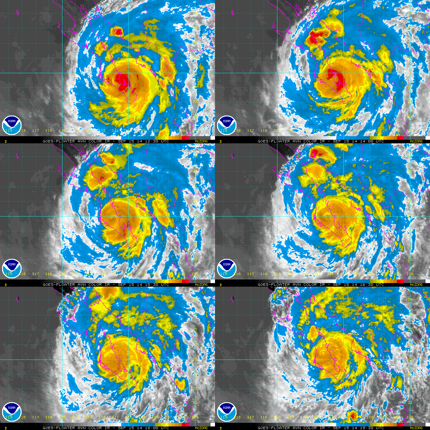
By WeatherFlow meteorologist Shea Gibson Hurricane Odile made land fall just over Cabo San Lucas as a Category 3 Hurricane at 9:45PM PDT, making it the strongest one to ever hit the Baja peninsula with winds packing 125mph and rains expected 6-12 inches or more. This is very recently after Category 3 Hurricane Norbert took a…

