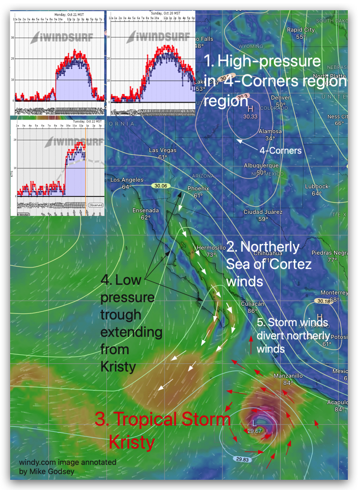
You know the old aphorism “If it looks like a duck, quacks like a duck…) Well sometimes it isn’t a duck. From the perspective of the La Ventana beaches it would appear that Sunday, Monday and today, Wednesday, we are having classic El Norte winds roaring down the Sea of Cortez. As you old time…
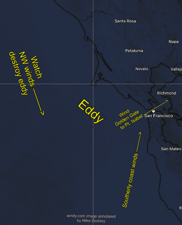
Preamble: Since the Bodega ocean buoy is NW 23g29, while the 449Hz profiler has average winds of 35 just aloft and my beloved Pt. Reyes is 23g3 I best will leave well enough alone: Sunday forecast: Powerful NW ocean winds obliterated the eddy and southerly coast winds as a massive, 3100 mile-wide North Pacific High…
Forecast Jargon Decoder: August 3, 2024 A broad streamer of dense low fog blankets the coast and Central Bay, but it shrinks to a narrow steamer that only impacts the Crissy winds. A rainy Gulf of Alaska storm crushes the North Pacific High’s surface NW winds against the west coast. So the NW ocean winds…
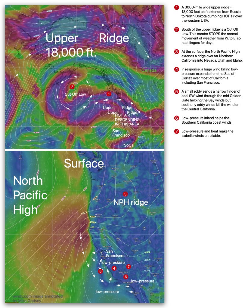
Forecast Jargon Decoder: Wednesday, July 3, 2024 BELOW the heat bubble created by a historic lingering heat wave, a tiny eddy off San Francisco sends a narrow finger of up and down upper-teens to low 20’s wind from mid Golden Gate to Brooks Island & Larkspur and maybe 3rd. Ave. Channel. Meanwhile, Arroyo, Pismo and…
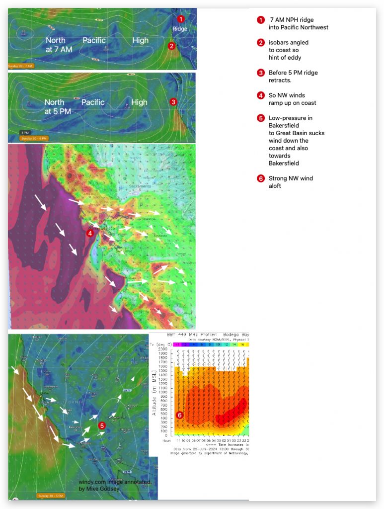
Forecast Jargon Decoder: June 30, 2024 It’s a fun day to arrive at Ocean Beach near dawn and watch the SSW eddy winds blow apart as big NW white caps reach the sand by 1 p.m. Ohh! Be sure to bring your kite! Expect upper-teens to mid 20’s winds on the ENTIRE coast, Crissy beach,…

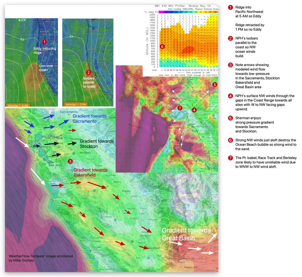
Forecast Jargon Decoder: June 29, 2024 Unsettled upper-teens to low 20’s winds focus in the mid Golden Gate to Pt. Isabel ton near Pt. Isabel to mid San Pablo Bay. Meanwhile, upper-teens winds are unsteady in the 3rd. Ave. Channel and especially near the launch sites late. This pattern develops as: 1. The North Pacific…
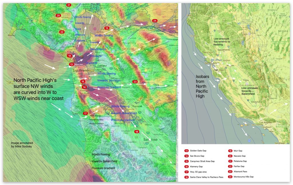
Forecast Jargon Decoder. Saturday, June 1, 2024 Ye Haw! Can you count to 7? It takes that many numbers to bring low to mid to upper 20’s+ winds to the entire coast and most of San Francisco as: 1. Overnight, the North Pacific High retracts the high-pressure ridge that caused the WSW coast eddy winds….
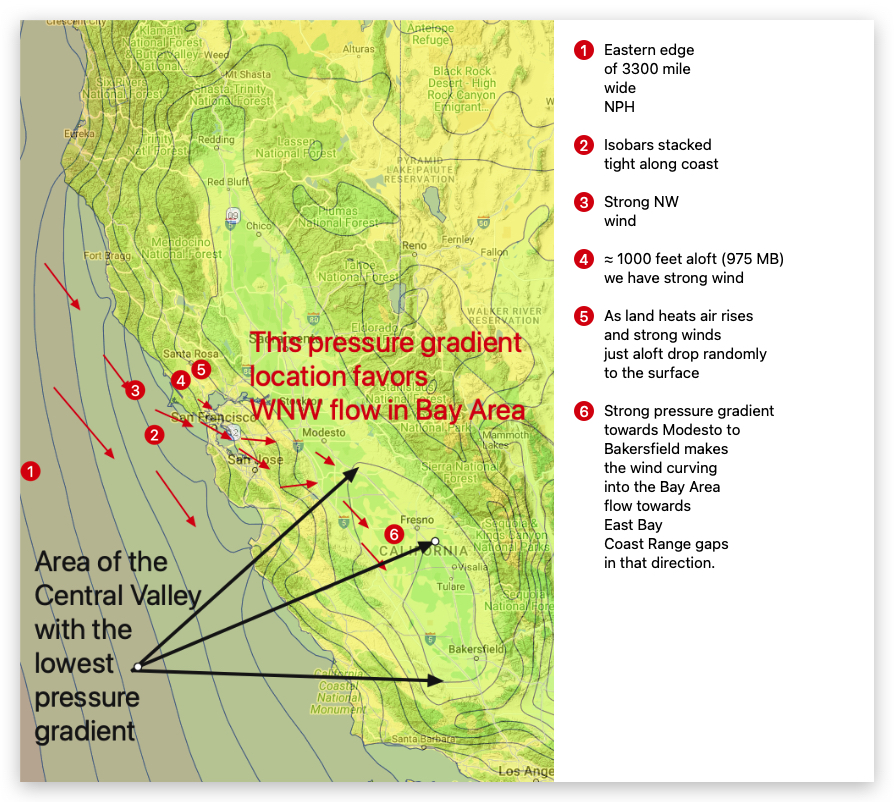
Thursday May 23, 2024 Todays forecast: Strong Gusty winds Coast, including OB and from Crissy to all Peninsula launch sites and outer waters + R&G and Sherman. The Bodega profiler shows 35 knot NW winds 200 meters aloft while Mt. Diablo is 28g34. This afternoon these winds blast to the surface due to: 1. A…
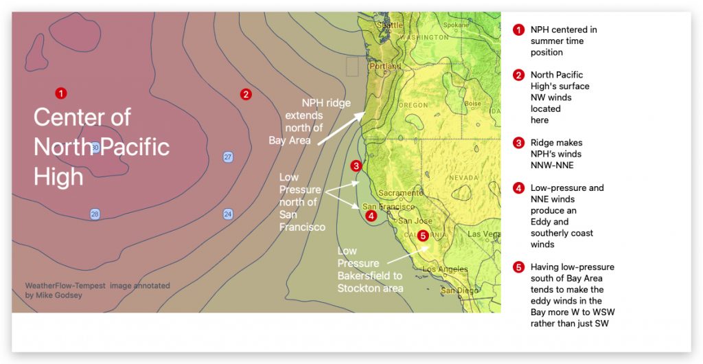
Mike Godsey Forecast Jargon Decoder: Wednesday, May 15, 2024 Despite the deep fog at 7 AM, the winds are already ripping in the SW-facing gaps in the Coast Range and at Point Blunt, Benicia, and Sherman Island. If you glance at a low-resolution model of the Pacific Ocean winds, you might expect strong NW winds…
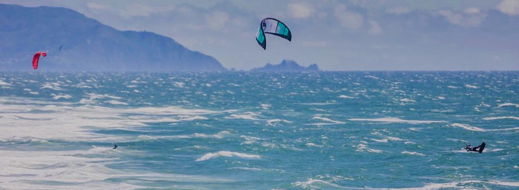
Mike Godsey These photos from the Ocean Beach King of the Cove event on April 26, 2024, tell the wind story. But if you need convincing that this was an epic day, look at the powerful winds at almost every WeatherFlow-Tempest shoreline sensor in the San Francisco Bay Area. The Red circles show sites with…