Baja Guide Links: Home | Human Forecasts | FAST forecast | Model forecasts | Road Rules | Driving Down | Baja wind | Windy sites | Food & Water | Resorts | Money, insurance, pets | Hurricane Diary | Zoom Baja Maps | Windless days | East Cape driving maps Ferry info. updated Oct. 30, 2008 Taking one of the ferries from the mainland to Baja is an adventure. If you are coming from the eastern USA, the ferry is going to be…
A tourist card is required except near the Tijuana-Ensenada-Tecate region. You will probably never be asked for a tourist card except possibly at Guerro Negro. But play it safe… get one. If you fly out of the country because of an emergency you wil be asked for a validated tourist card at the airport before…
Road report updated Monday Nov. 1&2 2012. Road report from Vagubundos: http//www.vagabundos.com/hotbox.htmRoad Report –BCS Route 1 Compiled November 1&2, 2012 The following information was compiled while driving South on Route 1 from Ensenada to La Paz on November 1 and 2, 2012. Ensenada to Guerrero Negro – two sections of road construction with some exposed…
Baja Guide Links: Home | Human Forecasts | Why Baja blows | Feedback: Baja forecast | Road Rules | Driving Down | Baja wind | Windy sites | Food & Water | Camping| Resorts | Money, insurance, pets | Hurricane Diary | Zoom Baja Maps | Windless days | East Cape driving maps | Fish/Surf | Baja photos | The Sea of Cortez, located between the Baja Peninsula and mainland Mexico offers world class kiting and windsurfing. The main windy season is from early-November to mid-March. However, there can…
Baja Guide Links: Home | Human Forecasts | FAST forecast | Why Baja blows | Feedback: Baja forecast | Model forecasts | Road Rules | Driving Down | Baja wind | Windy sites | Food & Water | Camping| Resorts | Money, insurance, pets | Hurricane Diary | Zoom Baja Maps | Windless days | East Cape driving maps | Wireless & Internet | Fish/Surf | Baja photos | Support local businesses | La Ventana turtles If the human onsite Baja forecast has not yet started when you arrive you can find wind reports and computer forecasting for Baja…
Baja Guide Links: Daily Human Forecast Home | Why Baja blows | Feedback: Baja forecast | | Road Rules | Driving Down | Where to go. | | Food & Water | Camping| Resorts | Money, insurance, pets | Hurricane Diary | Windless days | East Cape driving maps | Fish/Surf | Baja photos | This page has useful general information about driving in Baja. Each year the drive becomes easier and safer as the road and bridges improve but still it is different…
Baja Guide Links Daily Human Forecast Home | Why Baja blows | Feedback: Baja forecast | | Road Rules | Driving Down | Where to go. | | Food & Water | Camping| Resorts | Money, insurance, pets | Hurricane Diary | Windless days | East Cape driving maps | Fish/Surf | Baja photos | Driving down Baja this season? Be sure to see all the updates with close up maps and places to stay. Use the Driving Down link. A Baja trip is not just…
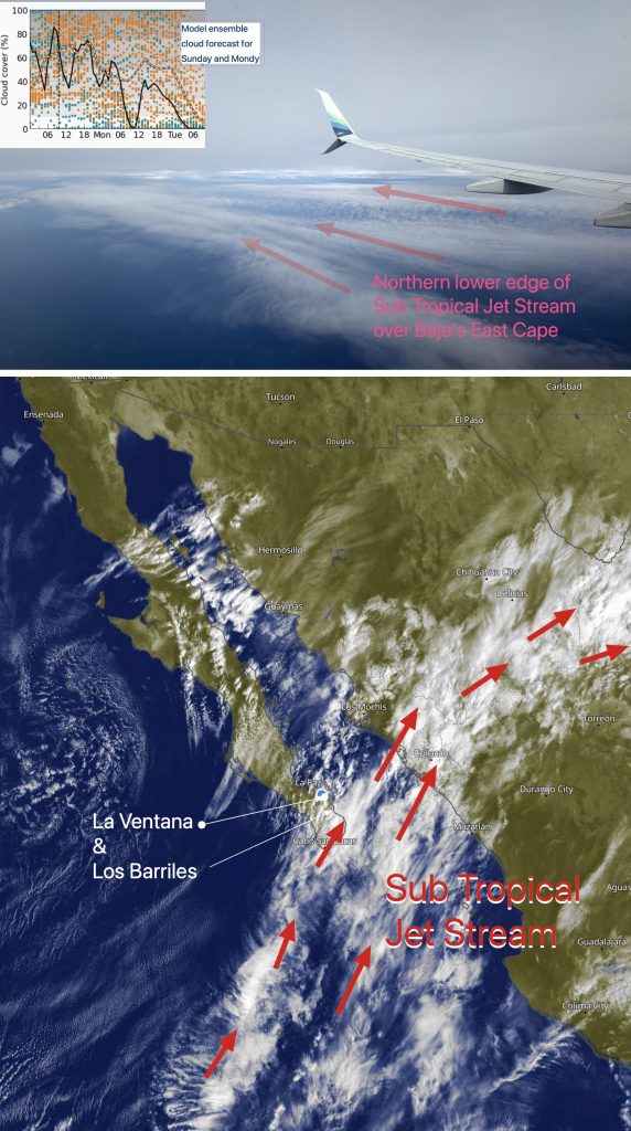
1- The dreaded Sub-Tropical Jet Stream is still streaming from the SW with 80% and decreasing cloud coverage and scattered sprinkles.2- These clouds will thin randomly, so Coastal Valley heating and thermal winds will not be reliable.3- A huge North Pacific High lords over the Pacific, and it is pushing high-pressure toward the 4-Corners region,…