Actual wind velocity HUMAN forecast for Rasta Beach, La Ventana and Los Barriles is located on ikitesurf.com iwindsurf.com sailflow.com and fishweather.com Today’s Wind Recipe: 1. To get the strong wind outside we need the heavy clouds to clear which is IFFY. 2. Strong NNW wind from the North Pacific High already streaming out by Isla…
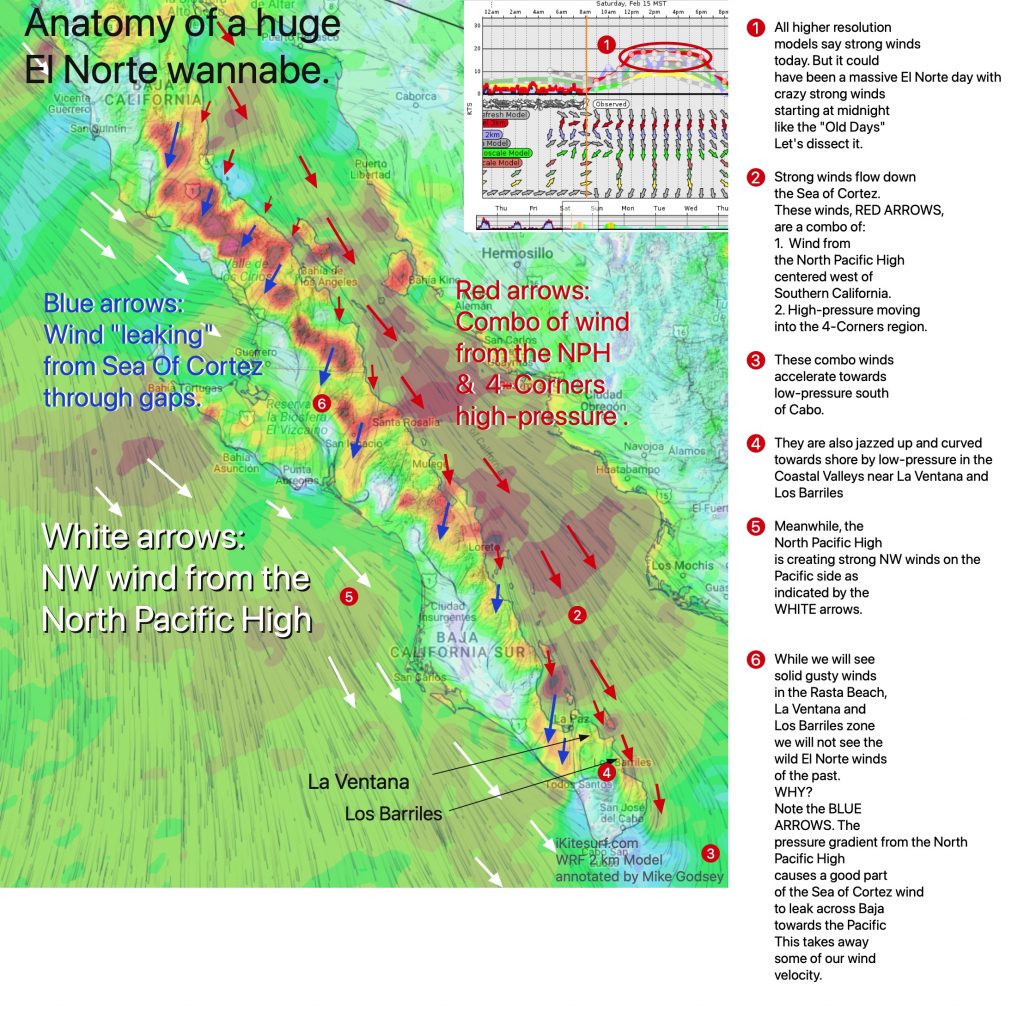
Looks like really good but gusty winds for Rasta Beach, La Ventana and Los Barriles Saturday 15. This is the same set up that used to give Baja’s East Cape wild El Norte winds that started at midnight and roared all day. Long time La Ventana full time resident Dean DeVolpi who lives next to the…
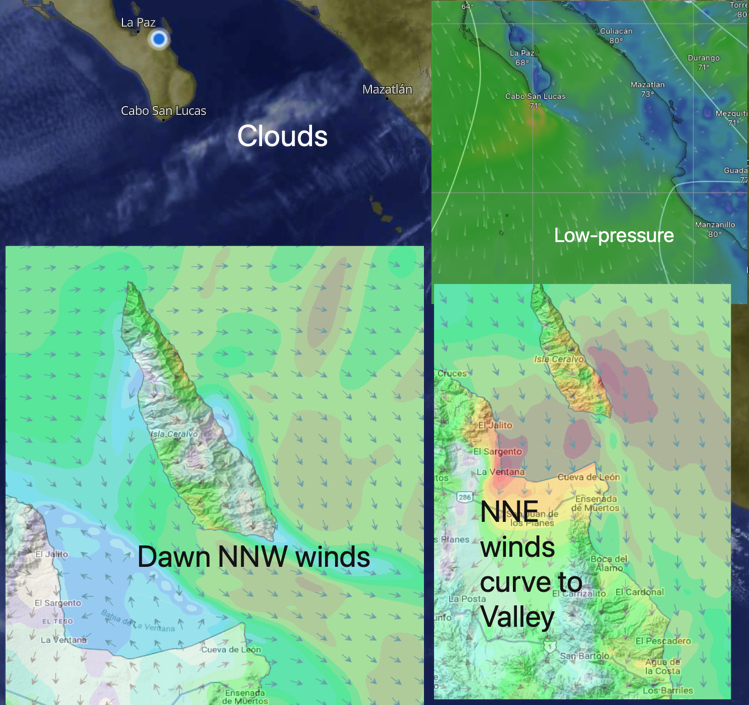
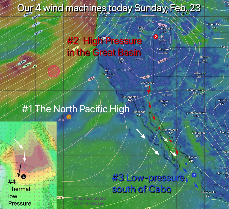
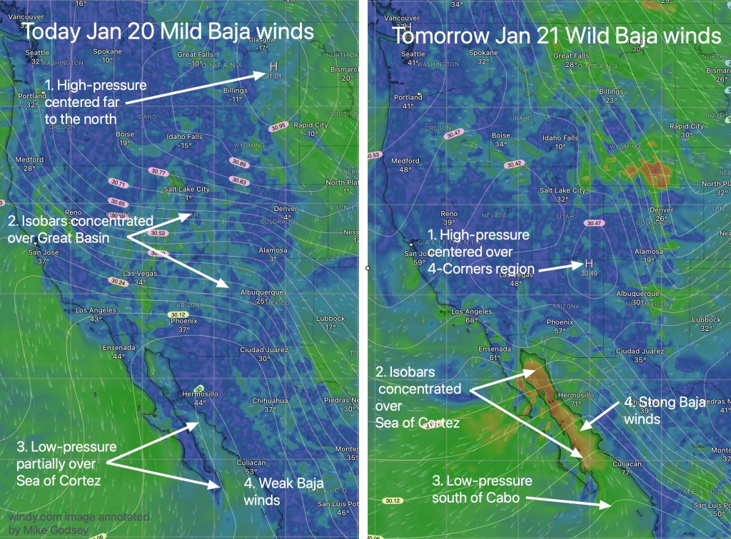
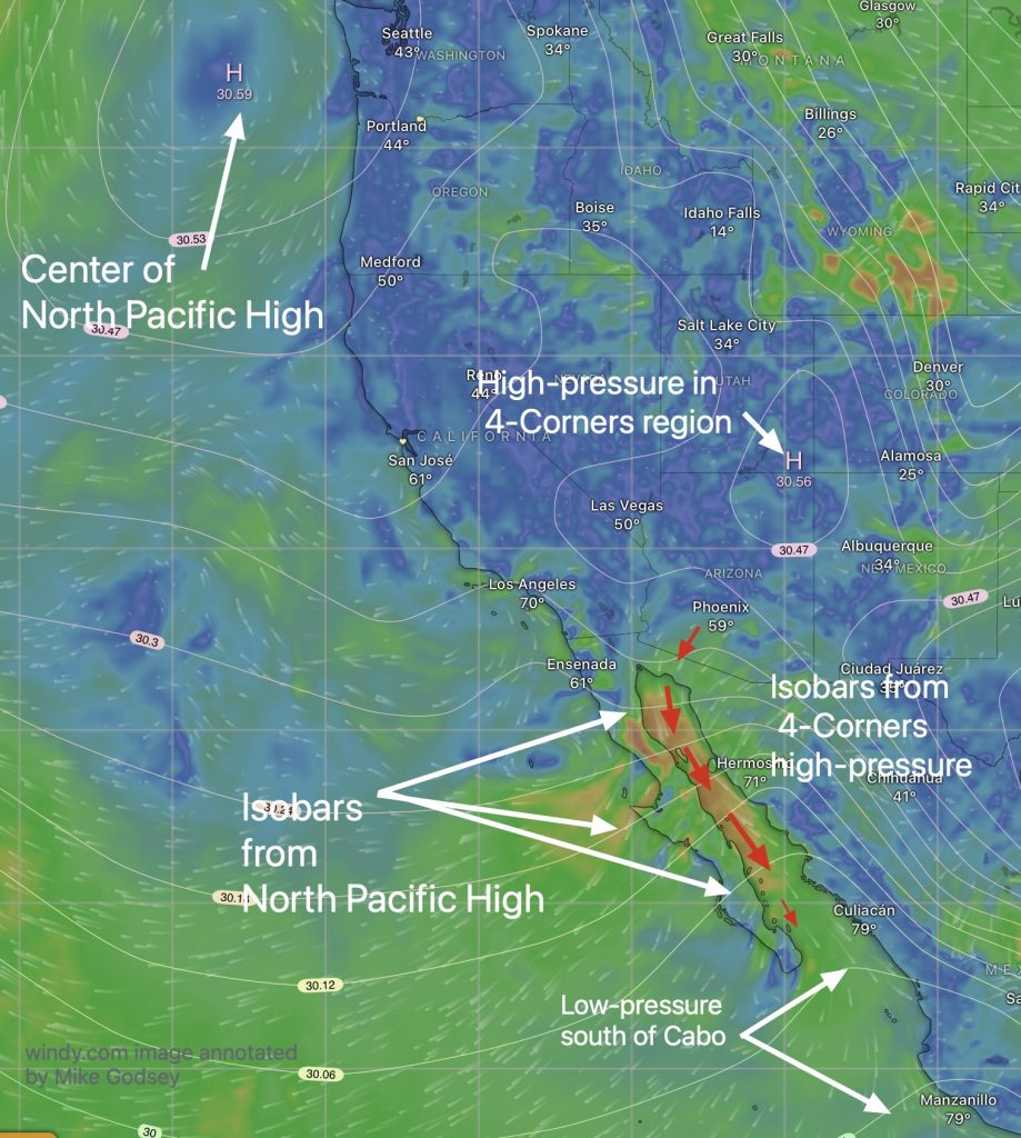
Strong NNE winds best at La Ventana, less reliable towards Rasta Beach and weaker for Los Barriles. (See ikitesurf.com for detailed forecast and velocity tables) 1, The wind killing clouds are now safely south of Cabo. 2. At dawn North Pacific High is sending strong NW winds down the Pacific side and some of that…
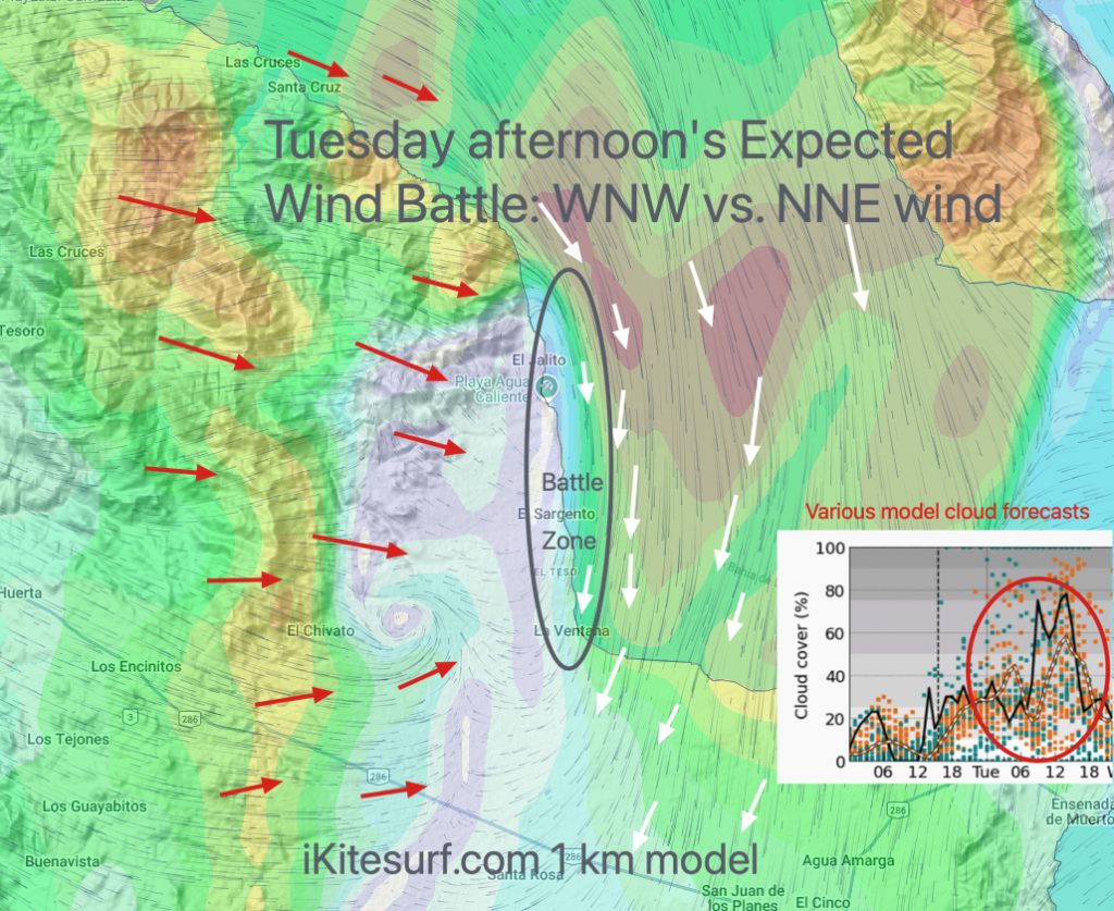
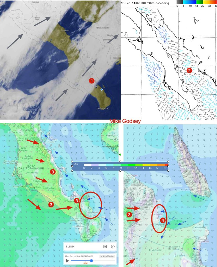
Wind Battle: WNW vs. NNE surface wind over the beach area. Remember the winds just aloft will probably be westerly. Things could change overnight but right now I would forecast unreliable winds near shore especially for Tuna to Rasta Beach. More reliable towards South Beach. Notice the possible wind killing cloud forecast if they are…
Bottom Line: Weak NE winds might briefly touch low-teens near La Ventana & a bit weaker Rasta Beach and faint for Los Barriles. Mid to upper NW winds on Pacific side. Today’s Wind Recipe: If you are a good cook you may know that sinking feeling when the pantry is bare and its 5 days…
Baja California forecast valid for Sat, Feb 8 2025 Late build reaches upper-teens with gusts over 20 strongest at Rasta Beach and La Ventana campground followed by Baja Joes and Los Barriles. Some forecast days are burgers, others are like Soufflés. A burger forecast is easy. Any mixture of the basic ingredients make it good,…
When you look at a model forecast one key thing to look for is the resolution. For an overall idea about the wind and weather for a large region a 9km or 5 km resolution model like you see on the amazing windy.com site is great. It is also excellent for extended forecasts. But when…

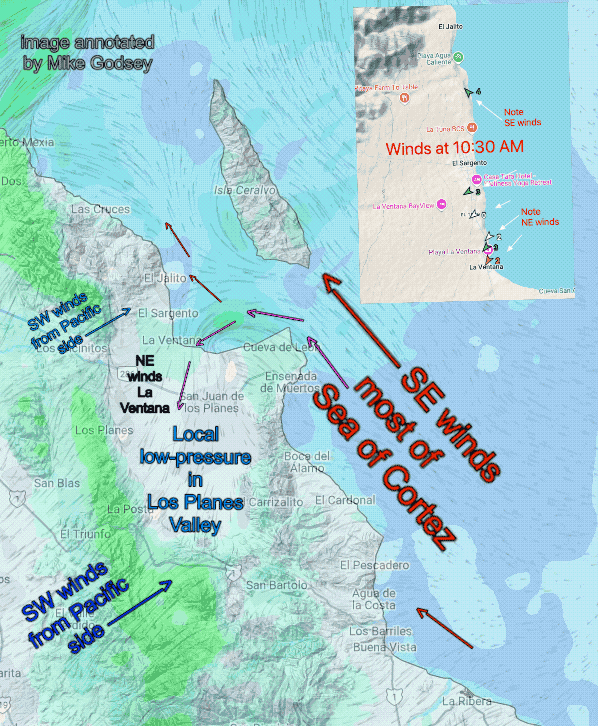
I am not forecasting today but there should be interesting winds. Cool dry strong El Norte winds to our north weaken in our area. But they may interact with moist warm southerly winds 9000 feet aloft. This happens as we begin a transition to southerly Sea of Cortez winds Saturday due to the Cut Off…
Limp winds today but tomorow “Small Dog Warning” winds for dawn as we see a Blast from the Past. Bottom Line: Possibly weak NE foil range winds with some strong N. gusts in the mountains. If you are camping, you best secure gear and small dogs in preparation for blasty predawn winds tomorrow especially near El…
So far the Baja 2024-25 winter wind season has been a great one with moderate winds almost every day. But one expected factor in the large scale wind recipe has been missing. Yes, the expected La Niña has been missing from the pacific weather patterns. Meteorologists have been expecting La Niña for months but in the…