by Mike Godsey, This was not supposed to happen. Today we were in a very clear eddy pattern with SW flow all day spoiling the 3rd Ave. winds. And with a huge eddy slated for tomorrow, there was not a chance that this eddy would die. And sure enough, by midmorning, anyone could see the…
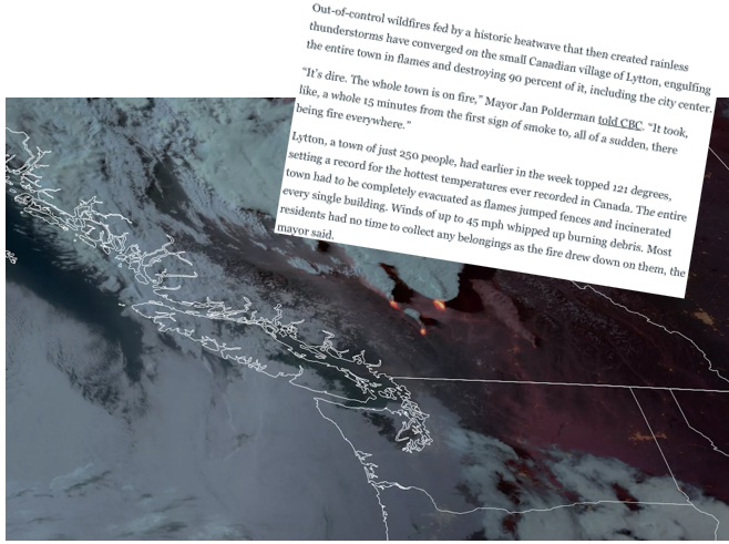
by Mike Godsey & Matt Souders The all-time record-breaking heatwave for the Pacific Northwest and western Canada is winding at least from the Coast to Gorge. This event brought Portland Oregon to an unbelievable 116 degrees. And much further north Lytton, which is about 155 miles east of Vancouver, British Columbia, reached 121 on Tuesday….
By Matt Souders & Mike Godsey Look at the headlines below and the fawn seeking refuge at Mike’s house from the Pacific Northwest’s worst heat wave since the 19th century. How did we get here? Well, it starts with warming high in the atmosphere. The jet stream is a belt of fast west winds that…
by Mike Godsey The coastal San Francisco Bay Area has seen an abrupt end of an oppressive heat wave during the last 12 hours. This occurred first as a Marine Surge arrived for Southern California waters bringing strong southerly winds, cooler air yesterday and after dusk fog. Then this morning this pattern was reinforced by…
A nagging upper high pressure has kept the San Francisco Bay Area hot for days. But far to the south it has been clear for several days that a Marine Surge was gathering steam for a lunge northward to the Golden Gate. (Here is a time-lapse video of a Marine Surge as seen from the…
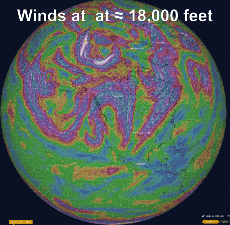
There is a lot of waffling in my forecast today since there are so many variables in play! A huge dome of high pressure at ≈ 18,000 feet has toppled many record temps in Northern California in the last few days. All this heat has caused low-pressure to expand over the East Bay making for unreliable…
by Mike Godsey The Central Coast and Southern California had a great spring and early summer with the North Pacific High’s NW winds hanging nearby most day. But this weak a massive upper level high pressure over the western USA brought an end to those winds. This first graphic shows the upper level high pressure…
by Mike Godsey, Indecisiveness I have inserted my forecast for today June 11 in this image so that you can see the indecisiveness in my forecast. The reason for this is that the San Francisco Bay Area is right intersection between 2 massive weather systems. First let’s take a close up view first to see the forecasting…
by Mike Godsey and Matt Sounders Have you ever noticed that meteorologists are usually pretty accurate about the temperature and the amount of sunshine but are so often way off when it comes to wind? Look at this graphic of the weather projections for today Sunday, May 28 by 10 major computer models for Treasure…