by Mike Godsey: Baja daily human forecast Questions about the forecast: Mail me mgodseywf@gmail.com Yesterday was a pretty wild day. It started with heavy clouds, scattered light rain and wild random gusts. But as I forecast the clouds cleared fast and the thermal effect of the inland valleys heating helped steady the wind…
by Mike Godsey: Baja daily human forecast Questions about the forecast: Mail me mgodseywf@gmail.com La Ventana often has nice sunsets but several times each season it has the most amazing sunrises you can imagine. My photo web site has lots of examples of these sunrises. Regular old sunrises are very simple. There are…
by Mike Godsey: Baja daily human forecast Questions about the forecast: Mail me mgodseywf@gmail.com It is rare to do a forecast and have the recipient of the forecast circle the cardon cactus over your house. But today we have to deal with a low pressure are to the north diverting our wind away…
by Mike Godsey: Baja daily human forecast Questions about the forecast: Mail me mgodseywf@gmail.com La Ventana is renowned for being a window to spectacular SUNRISES. Of course, there is a demographic which has been coming here for years and has yet to see a sunrise. But as my banner photo shot, last Saturday…
by Mike Godsey: Baja daily human forecast Questions about the forecast: Mail me mgodseywf@gmail.com Part one of this blog discussed the basic causes of the low-pressure trough that helps our El Norte winds flow down the Sea of Cortez. This blog focuses on the role of topography in shaping that low-pressure trough. As…
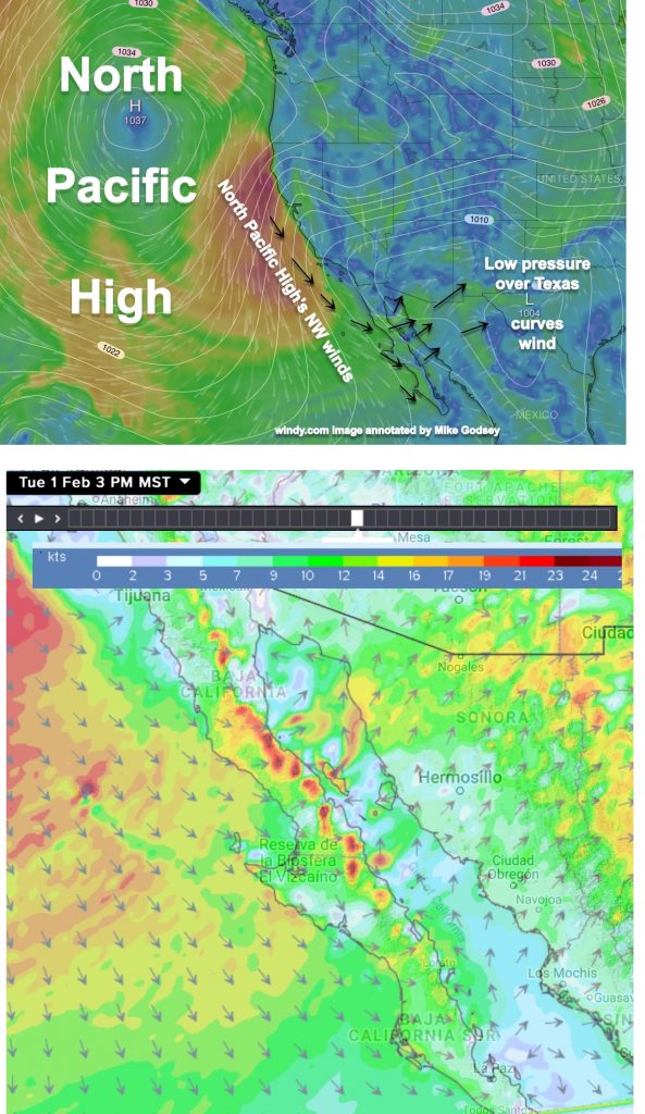
by Mike Godsey: Baja daily human forecast Questions about the forecast: Mail me mgodseywf@gmail.com I always talk about high pressure and our northerly winds. Mostly I labor over the location of high pressure in the Great Basin and 4 corners. And sometimes I mention the winds of the North Pacific High that span…
by Mike Godsey: Baja daily human forecast Questions about the forecast: Mail me mgodseywf@gmail.com The cloud situation threatened the quailty of the winds yesterday but the expected hole in the clouds arrived mid day and lead to complete clearing. Hence the strong forecast winds arrived.
by Mike Godsey: Baja daily human forecast Questions about the forecast: Mail me mgodseywf@gmail.com Clouds will be the deciding factor in today’s forecast as you can see in this first image Ignoring the clouds for now…today has the potential to be a classic El Norte wind with the bulk of the wind coming…
by Mike Godsey: Baja daily human forecast Questions about the forecast: Mail me mgodseywf@gmail.com We are not the only critters that travel using the Sea of Cortez winds. These ocean-going gastropods (snails) use their air bladder to stay afloat but also to ride the wind. Like us, they sometimes make poor decisions and…
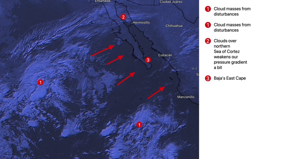
by Mike Godsey: Baja daily human forecast Questions about the forecast: Mail me mgodseywf@gmail.com Yesterday, I mentioned that moderate to strong El Norte winds were likely today. However, with my extremely slow internet connection I can often can not look at all the variables. Now in this inky predawn the satellite shows some…