Forecast Jargon Decoder:
Oct. 17, 2024
Strong NNW winds just aloft battle with very strong WNW surface winds curving into the Bay making for Blasts and Lulls from hell.
Note: Use extreme caution launching kites today!
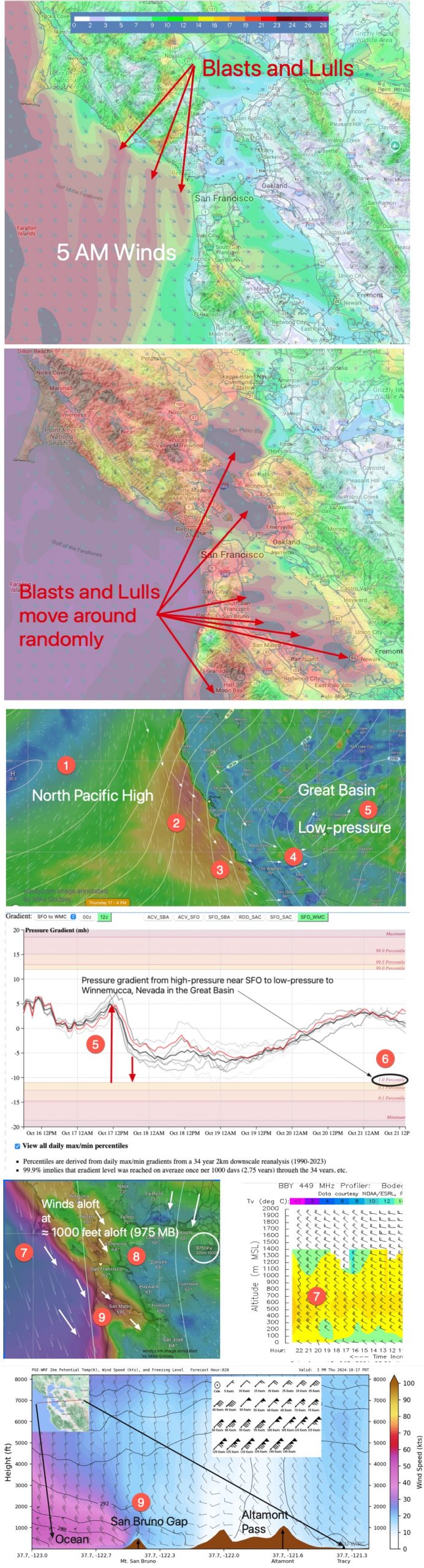
Look at today’s Blog for the Bays modeled winds at 5 AM and 4 PM.
The crazy strong winds splotches of exceptional strong winds that will shift about during the day.
Here is the story:
1. The North Pacific High is exceptionally large and north of its normal fall location.
2. Its isobars are being compacted against the California coast from Pt. Arena to Jalama by a Pacific storm to the west.
3. This is causing strong NW ocean winds along the coast with Marin’s Pt. Reyes already showing 24g33 and the Santa Maria Ocean buoy already 15g19.
4. in the AM these NW ocean winds roar down the West Coast enter to the Central California coast then near SoCal waters they curve inland over lake Isabella towards…
5. Low-pressure in the Great Basin, which deepens as a Cut-Off Low far loft begins to form.
6. By this afternoon this causes a 98% percentile pressure gradient to form between SFO and Winnemucca, NV, so very strong NNW to WNW enters the Bay.
That NNW winds causes a weak lingering eddy for most of SoCal.
7. At the same time, in the Bay Area, at ≈ 1000 feet aloft very strong NNE to NNW winds hit the Coast Range, become turbulent and create BLASTS, LULLS and SHIFTS in the surface wind.
8. All this makes the Pt. Isabel to Berkeley winds unreliable.
9. As these winds hit San Bruno Gap and mountain, they add UP AND DOWN momentum to the Coyote and 3rd launch sites surface winds.