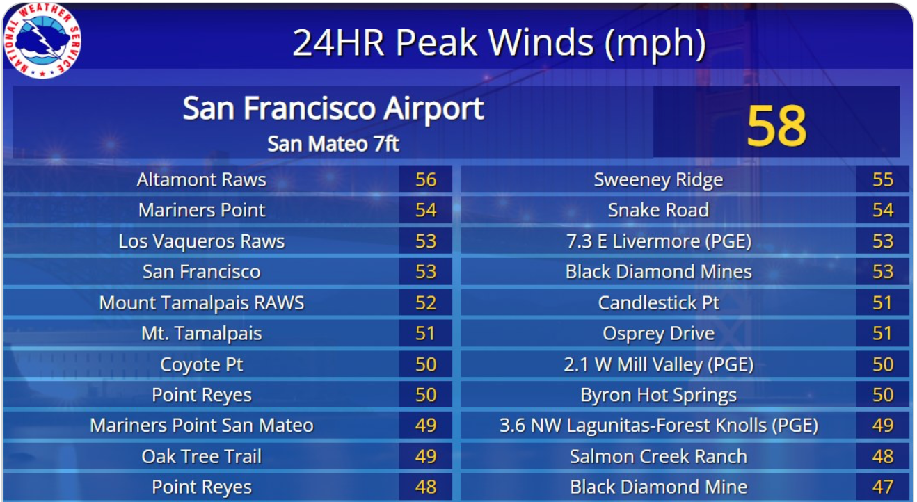
June 20 & 21 the Bay Area saw a significant high-wind event, marked by a notable absence of the typical June Gloom marine layer clouds and ferocious surface gusts exceeding 50 knots.
These winds had the clear signature of an exceptionally powerful and unusually low-altitude California Coastal Low-Level Jet (CLLJ).
The powerhouse behind any wind is a difference in air pressure.
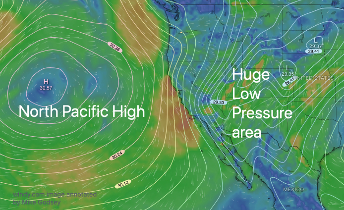
This event started as a very strong 3000 mile-wide and North Pacific High which created a massive dome of dense, sinking air offshore and very strong NW ocean surface winds’ These winds ripped along the California coast from near Cape Mendocino to Pt. Conception.
Simultaneously, the intense heating of the land in the Central Valley, especially in the Stockton to Bakersfield area and Great Basin generated a deep, expansive area of low pressure.
During this wind event both the North Pacific High and the Great Basin low-pressure were greatly
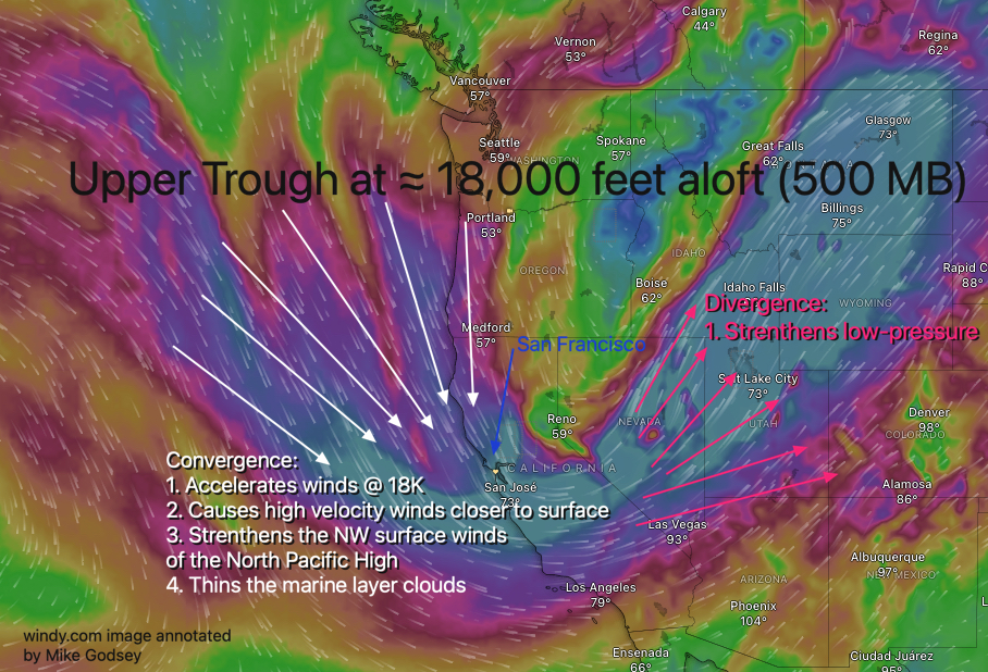
strengthened by an upper trough far aloft.
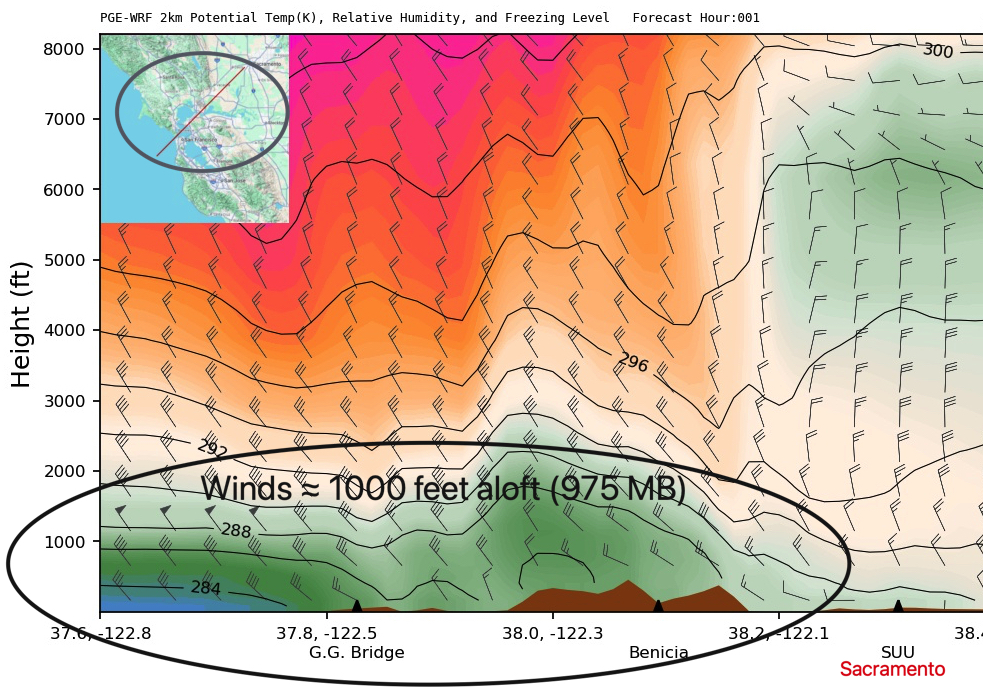
This graphic briefly summarizes how the upper trough impacted the wind event.
The dramatic difference in pressure between NPH and the inland low-pressure created a very steep “pressure gradient.”
Just as water flows more forcefully down a steeper hill, this steep gradient initiated a powerful flow of air
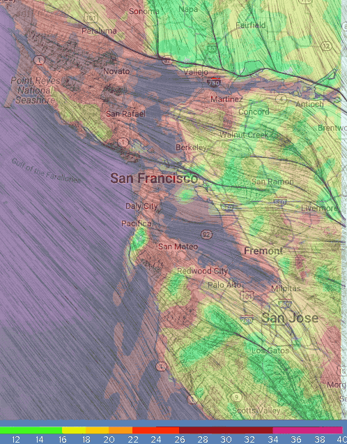
from high to low pressure—the strong northwesterly ocean surface winds that curved through near coast gaps like the Golden Gate and San Bruno Gap and then curved towards other gaps in the East Bay Coast Range leading to the Central Valley.
As wind near the East Bay Coast Range they curve towards those gaps lead towards the strongest pressure gradient. And this determines which launch sites have the strongest winds and the direction of those launch site winds.
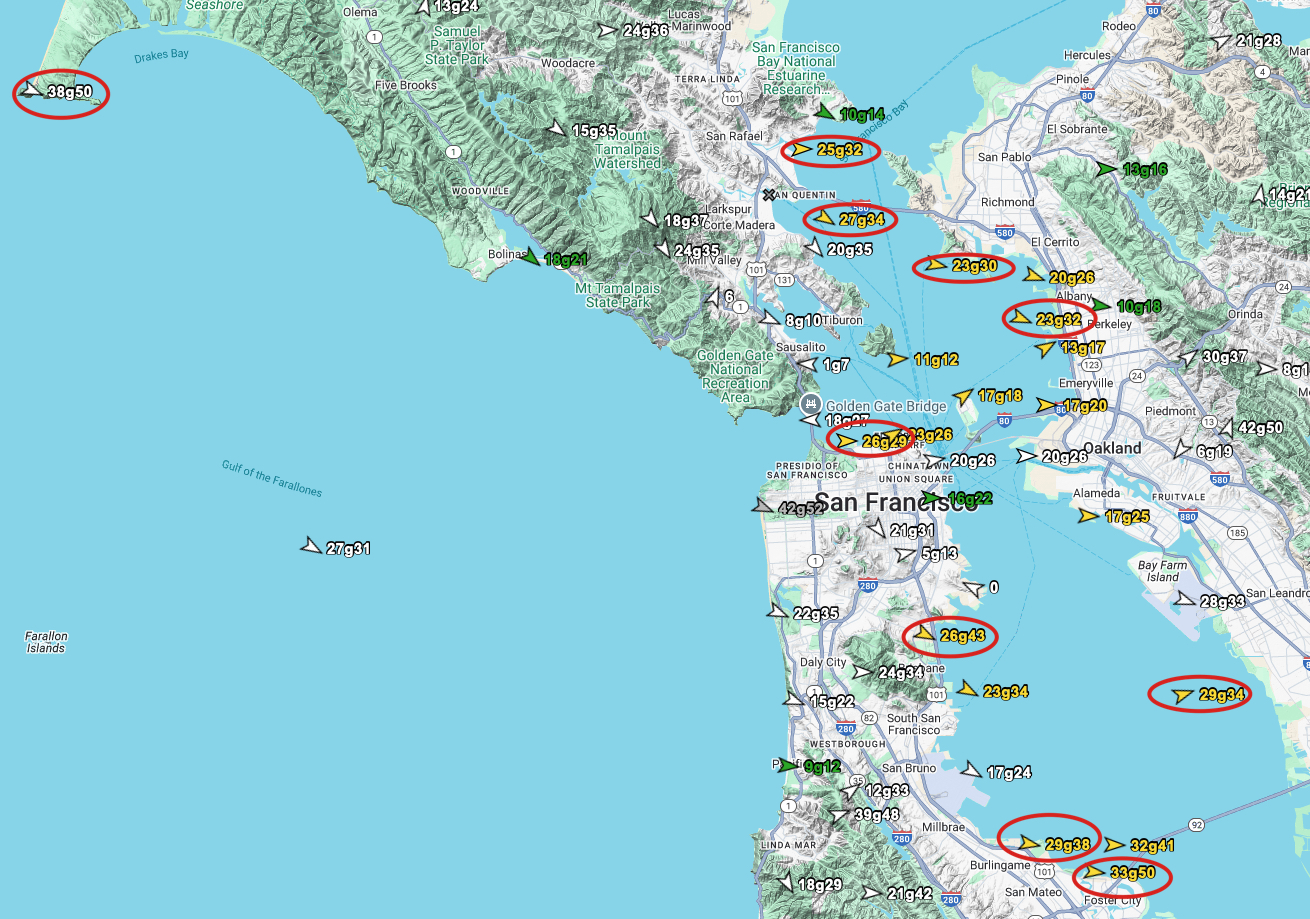
Typical 20-30 knot NW winds: Often in the late spring and early summer the zone from Crissy to Treasure Island and the Peninsula receive strong winds curving in from the ocean. This event was different.
30-50 knots is NOT typical NW winds: The crazy strong winds we observed Friday and Saturday point to a more nuanced and potent version of this a NW wind event.
Here are crucial details behind this wind event:
1- Historically the Bay Area often has a “June Gloom”.
This happens as a deep, moist layer of air that forms clouds when it’s cooled by upwelling of chilly water near the coast.
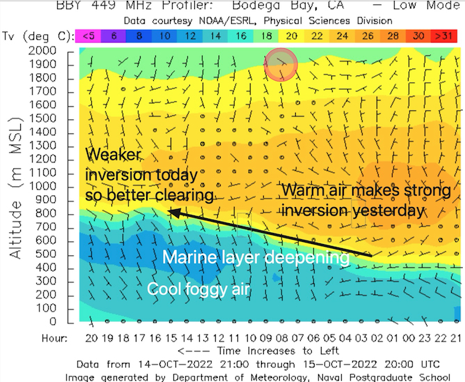
These marine layer clouds are usually capped by an inversion of warmer air that acts as a “lid” separating the surface winds from the winds just aloft.
2- During the Friday and Saturday event the immense North Pacific High compressed the marine layer almost to the surface.
The temperature inversion (the “lid” on the marine air) was still present but it was diffuse and forced down to a much lower altitude.
3- At the same time temperature differences between the coastal air and inland air helped for a low-level jet over the coast and Bay Area. You can see these powerful winds in this Bodega Profiler image.
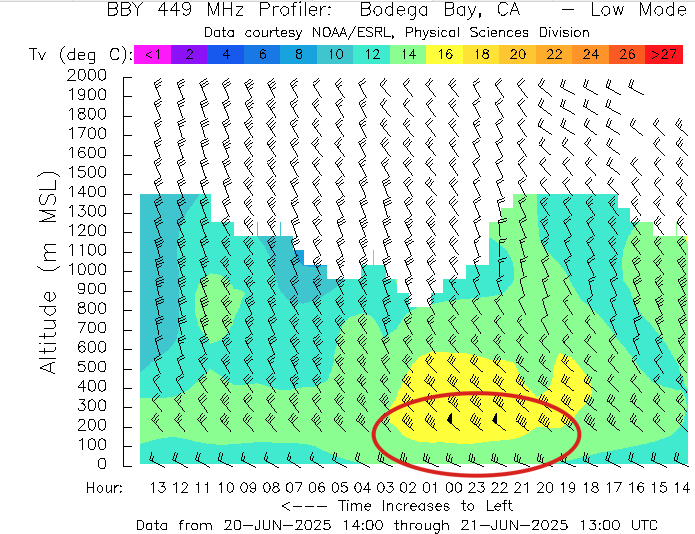
Low-level jets are usually roughly parallel to the California coast and are common along the west coast ABOVE the marine layer during summer.
The data suggests that part of this Low-level jet came over the Bay Area at very low levels during this event.
(I should point out that the term “low level jet stream” which sounds like a combination of “low level jet” and “jet stream”. Both are completely different meteorological phenomena)
The Low-level jet often has wind speeds in near 60 knots and is typically situated near inversion at the top of the marine boundary layer.
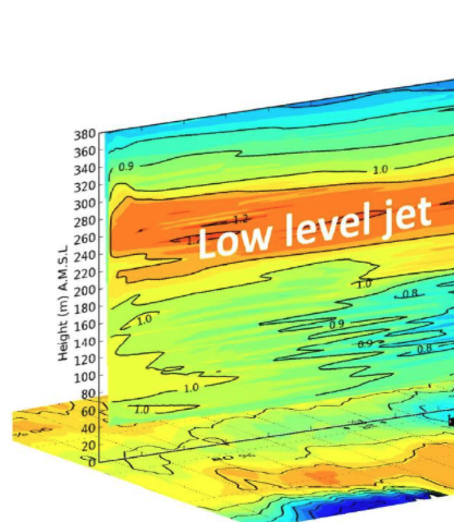
4- With the jet’s core located just at the top of this weak inversion or lid, the fastest jet winds were positioned much closer to the ocean’s surface from the start and could interact with the inbound ocean winds.
5- The combo of these powerful winds acted to “scour out” and erode any remaining early morning cloud
deck through mixing. This brought the jet winds even closer to the surface ocean winds. Even near dawn these strong winds were creating standing waves in the sparse marine layer clouds outside the Golden Gate.
6- While the effect of this lower, more powerful jet was strong at our ocean buoys ≈11 miles off shore t sea level the winds were much stronger inside the Bay Area. Why?
6- As the massive volume of fast-moving, low-level air slammed into the Coast Range, it had to go
somewhere.
While the ridge tops were battered by being directly in the path of the jet’s core, the 35+ knot gusts on the Bay waters were caused by a funneling effect.
7- Coast Range gaps like the Golden Gate, the Petaluma Gap, Alemany Gap, Hwy. 92 gap, and the San Bruno Gap acted as natural nozzles, funneling the air and forcing it to accelerate dramatically as it squeezed through—a phenomenon known as the Venturi effect.
It is not by chance that almost every site frequented by winds sport folks is down winds of one or more of these gaps in the Coast Range.
8- Because the jet’s core was already so low, these gaps tapped directly into that high-velocity flow, channeling it down to the surface and creating the powerful winds observed.
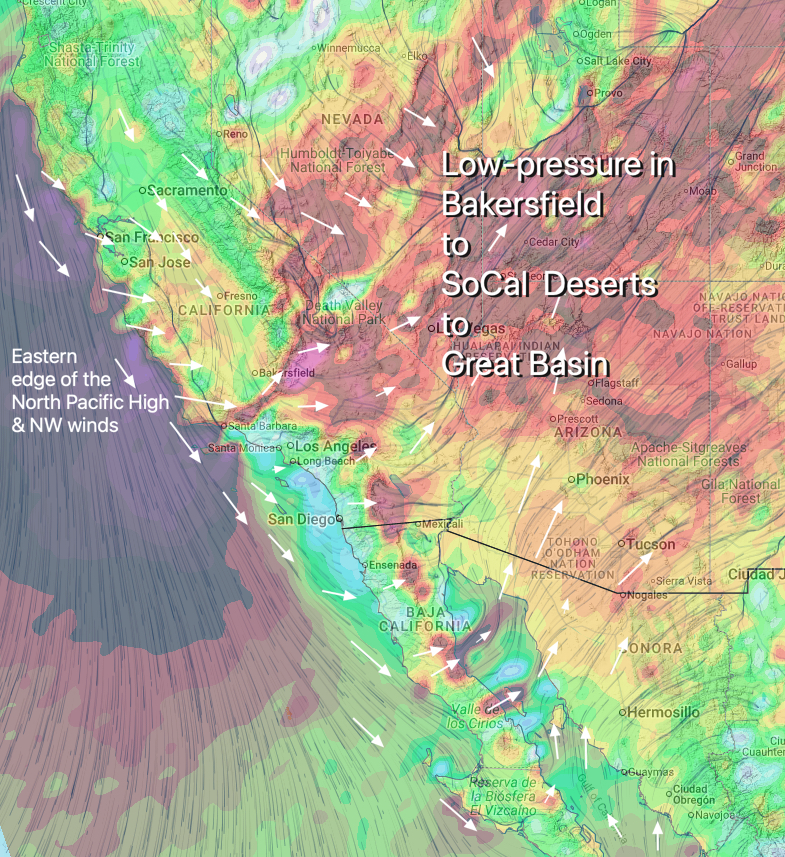
9- Once these winds were over the Bay waters they had to find a pathway to the low-pressure towards Bakersfield, Stockton and the Great Basin.
Typically winds cross the Bay waters seeking the most direct gaps in the East Bay Coast Range leading to the low-pressure.
While that did occur during the recent event there was so much air moving towards the low-pressure that it also took pathway OVER the Coast Range. Hence the powerful ridge gap winds.
In summary, this past weekend was not just a typical windy day. It was a powerful demonstration of what happens when a massive-scale pressure gradient creates an exceptionally strong low-level jet and positions it closer to the ground. The absence of clouds was a tell-tale sign of this compressed atmospheric state, and the ferocious winds ripping through and over the coastal gaps were the direct, ground-level consequence of this potent, low-flying river of air interacting with our local topography.