From 7:30 AM: Let’s play Meteorology 101! Which sites will be windy today!
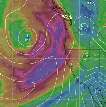
- Find any model page that shows the isobars near the west
coast.
2. Zoom in to the Pacific off California and notice the spiral off Oregon. That is the Cut Off Low that is deepening our marine layer and making southerly wind for the far Northern California coast.
3. Now look south of the Cut Off Low and notice the isobars roughly parallel to our coast south of the low. Those represent the pressure gradient from the North Pacific High that creates NW wind.
4. Now jump to your iw or ik app and confirm that our ocean buoys are seeing moderate NW winds.
5. Now go to a satellite page. Of course, the entire greater Bay Area is engulfed in fog but notice the major fog bulge towards Stockton, which suggests a pressure gradient in that direction which you can confirm by looking at the barometer reading. This promises Pt. Isabel and Berkeley wind. Most importantly, if you live in the Peninsula is the heavy rivers of fog streaming southward in San Jose’s Santa Clara Valley from San Jose to near Pacheco Pass and on to the Salinas Valley. This suggests a pressure gradient to Bakersfield.
6. To confirm this gradient go back to the page with isobars and zoom into California. Notice the isobars extending from the Southern California Deserts over Bakersfield to Fresno? If it holds it will suck wind from San Bruno Gap over the 3rd Ave. Channel and probably the launch sites.
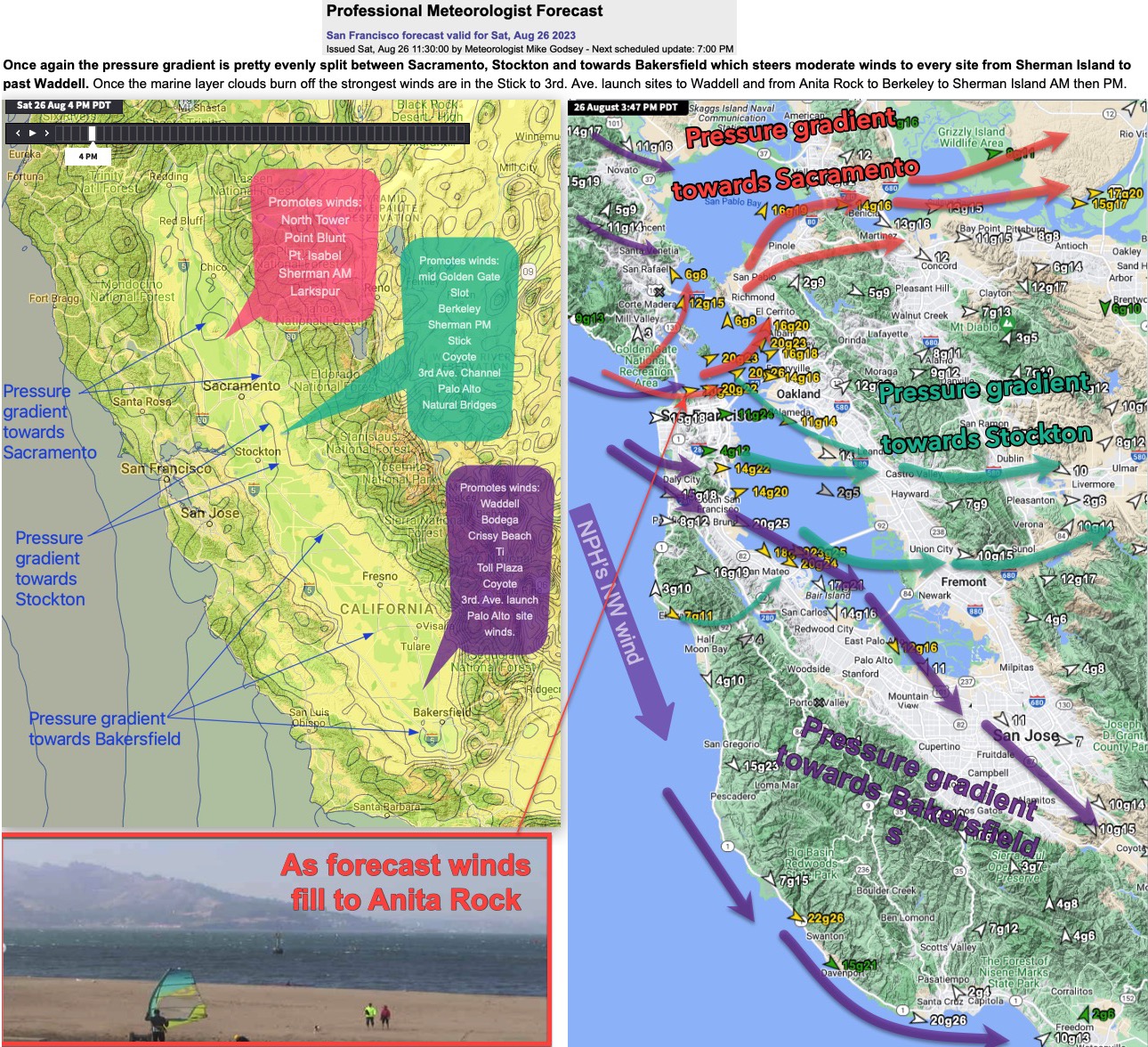
7/ Keep working on this for every site in the Bay Area and you will create a mental picture much like my graphic. From which you could conclude…
Once again the pressure gradient is pretty evenly split between Sacramento, Stockton and towards Bakersfield which steers moderate winds to every site from Sherman Island to past Waddell. Once the marine layer clouds burn off the strongest winds are in the Stick to 3rd. Ave. launch sites to Waddell and from Anita Rock to Berkeley to Sherman Island AM then PM.
Update at 11:30 AM: The Brandt’s cormorants on Año Nuevo have sharp shadows so Waddell is good to go. And NW wind at Half Moon Bay and NW in the Santa Clara Valley + the San Bruno Mountain cam which show fast-moving WNW fog and all our Tempest sensors in the San Bruno Gap are WNW. So I am sticking to my forecast for good WNW winds at the 3rd. Ave. launch sites. Meanwhile, Sherman is showing the expected midday lull. The Golden Gate to Pt. Isabel and Berkeley zone awaits clearing and I am sticking to my forecast for that zone. The only area in question is the Crissy to Anita Rock zone. The highest-resolution fog models suggest a broad fog streamer lingers near that area so probably only brief winds in the forecast range.