by Mike Godsey
Forecast Jargon Decoder: Monday April 1, 2024
As a storm departs Southern Californians moves into the Great Basin the North Pacific High’s surface NW winds ramp up on the Pacific side along with huge swell.
The North Pacific High’s winds take two pathways in Baja Sur:
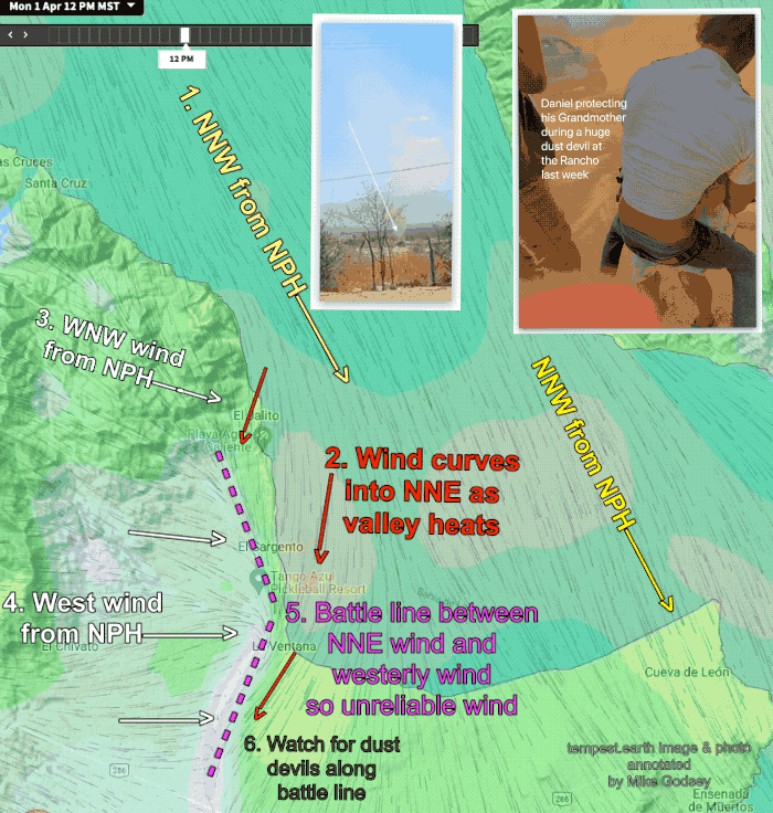
1. Part of the wind flows down the Sea of Cortez and arrives near the Rasta Beach to La Ventana to Los Barriles zone as NNW wind. As these NNW wind near the coast they are curved into favorable NNE wind.
2. But some of the NPH’s winds flows across the Baja Peninsula from the Pacific and nears the La Ventana beaches as very unfavorable W. to WNW winds. This is especially true for locations near arroyos.
So today our beach winds have the potential of reaching the upper-teens to low 20’s
But the afternoon strong unfavorable WEST winds at the surface and just aloft will fight with the favorable NNE surface winds.
This will probably make the beach winds unreliable especially in the Rasta area but also in La Ventana. Notice the battle line in this graphic. If that battle line is more inland we could have good beach winds. If the battle line is over the coast (which is more likely in the Rasta Beach area) the winds near shore will be very unreliable.
Also, along that battle line there will be a lot of wind shear that often produces huge dust devils. We were out at the Rancho last week in a similar pattern. We were digging up a large coconut palm in calm winds. Suddenly the visibility went to near zero and we were caught in swirling 50 knot winds and dust. I could not even see my camera as I tried to photo the experience. So I just kept jabbing my fingers on my screen hoping to get any image. As the dust devil departed I capture the image in the graphic of Daniel stopping his grandmother from toppling in the strong winds.
Los Barriles is more protected from the westerly winds so the beach winds will be more reliable.