Hi Michael,
Welcome back to the sport!
Skip to the bottom of this blog for the fast answer to your question.
Background:
3rd. Ave. is one of the most complex places in the Bay Area to forecast. It is fed strong ocean WNW to NW wind from the San Bruno Gap and usually weaker W to WSW flow from the Hwy. 92 gap area. This creates a battleline between those 2 winds. This means that the wind at the 3rd. Ave. launch sites can be very different than the wind in the 3rd Ave. Channel. If that battleline is west of the launches then you have a good day. If the battle line is over the launch sites then you have unreliable on and off winds shore despite good WNW winds in the channel. If the battleline is over the channel you only have useless southerly winds.
What determines the location of the WNW vs. WSW battleline? That is determined primarily by the
direction of the max pressure gradient. If the max pressure gradient is towards Bakersfield via the Santa Clara Valley from San Jose to Pacheco Pass then the WNW winds from San Bruno Gap hit both the 3rd. Ave. launch sites and the channel. If the max pressure gradient is towards the Stockton area via the San Leandro Channel to Hayward to East Bay Coast Range passes then the WNW wind from San Bruno Gap curves eastward a bit moving away from the 3rd. Ave. launch sites while attracting the WSW flow from the Hwy. 92 gap area WSW winds.
So to answer your question more specifically:
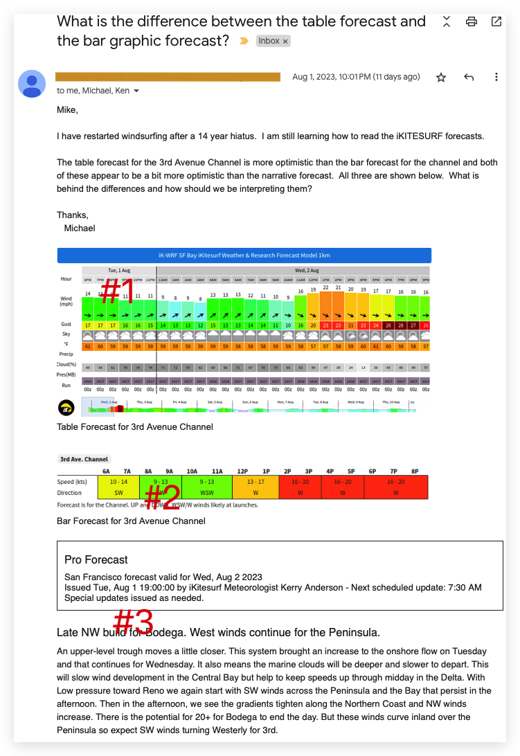
1. The first table in your graphic (below) is what our 1 km WRF model forecasts as the mean wind in the 1km area between the launch sites and the channel. The problem with that forecast is that it does not see the battle line.
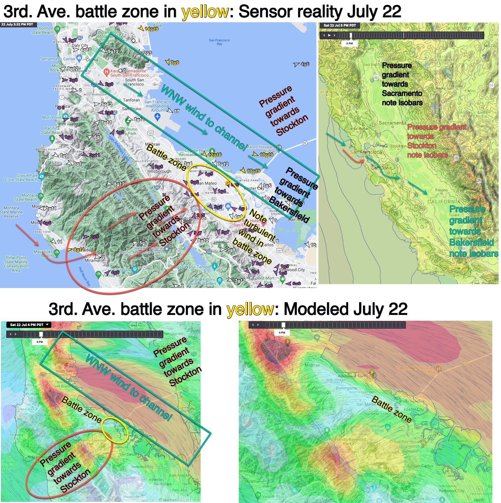
2. The second table in your imagery is filled in by hand by the met. on duty. It basically gives the same data but fudged to partially allow for the difference between the winds near shore and in the channel.
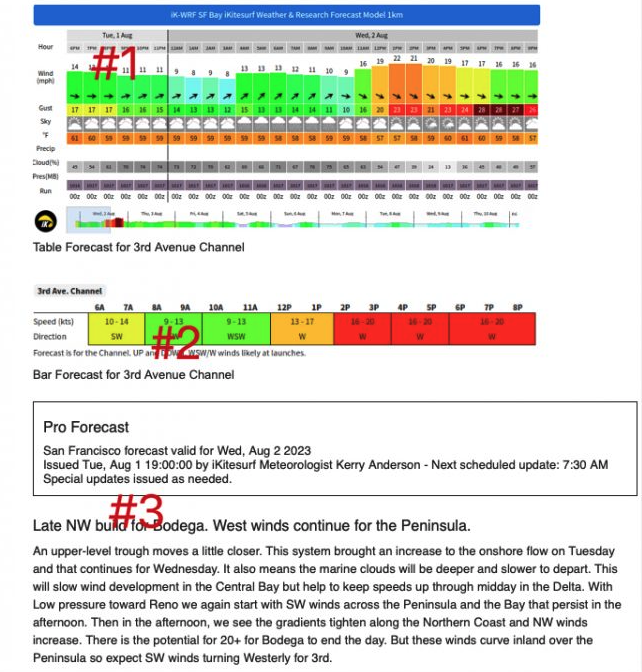
3. The human “Pro forecast” gives the mets best shot at forecasting the winds at the launch site. On this day Kerry is saying that despite the optimistic table forecasts there may be crappy WSW winds at the launch site.
The problem in the last decade for 3rd. Ave. is:
1. Counter-clockwise eddies have become way more common along the Bay Area coast. We are good at forecasting when an eddy will form but so far we struggle forecasting when an eddy’s southerly winds will subside. And that determines where that battleline will be located near 3rd. Likewise, we are good at forecasting in the AM where the max pressure gradient will be regarding Bakersfield vs. Stockton but that can change in the afternoon.
2. The same variables that create more eddies have shifted the max pressure gradient northward which encourages WSW flow from the Hwy. 92 gap area hence more problematic 3rd. Ave. launch site winds.
So, bottomline, most of the time looking at the human filled table plus the text will usually give you the best forecast. But watching an animation of satellite imagery, cams and all the sensors between Half Moon Bay and 3rd. Ave. will fine tune your decision. We used to publish a computer Half Moon Bay forecast which really helped with decision but we stopped doing that.
Here are blogs about how to do this: https://blog.weatherflow.com/west-coast-wind-blog-3rd-ave-launch-site-winds-tools-of-the-trade/, https://blog.weatherflow.com/west-coast-wind-blog-how-to-judge-the-likelihood-of-wsw-evil-wind-at-3rd-ave-launch-sites/,https://blog.weatherflow.com/west-coast-wind-blog-modeled-3rd-ave-battleline-today-between-good-and-evil-wind/, https://blog.weatherflow.com/west-coast-wind-blog-developing-battle-between-wnw-and-wsw-flow-that-will-play-out-near-3rd-ave-and-near-pt-isabel-and-berkeley-today/
Hope all this helps.
Mike Godsey