
VERY ROUGH DRAFT
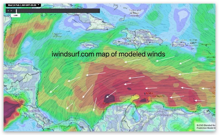
The topography of a Caribbean island and the strength of the trade winds can have a significant impact on each other. Here’s how: https://wx.iwindsurf.com/map#15.834,-76.217,6,297723
https://www.sciencedirect.com/science/article/abs/pii/S1364032113006771
Trade winds:https://wx.iwindsurf.com/map#15.834,-76.217,6,297723
-
- Average speeds: The Trade winds velocity varies greatly depending where you are in the Caribbean and which side of an island you are on and if you are in a narrow channel between islands.
- At exposed location on the windward side of an island the Trade winds typically range from 10 to 20 knots (18-37 km/h) throughout the Caribbean, with gusts exceeding 30 knots (56 km/h) possible in localized areas. While on the leeward side, especially if there are mountains the Trades can be faint.
-
- Seasonal variations: During the peak Trade Wind season (December-February), average speeds can reach 15-20 knots (28-37 km/h), compared to 10-15 knots (18-28 km/h) in the summer months (June-August).
-
- Pressure differences: The strength of trade winds is directly related to the pressure gradient between the Nort Atlantic High-pressure and the equatorial low towards Central America and the Pacific. Stronger pressure differences lead to stronger winds.
-
- Impact on climate: Trade winds play a crucial role in shaping the climate of the Caribbean islands. They bring cooler air and moisture, contributing to pleasant temperatures and regular rainfall patterns.
Island topography:
The Venturi effect in general:
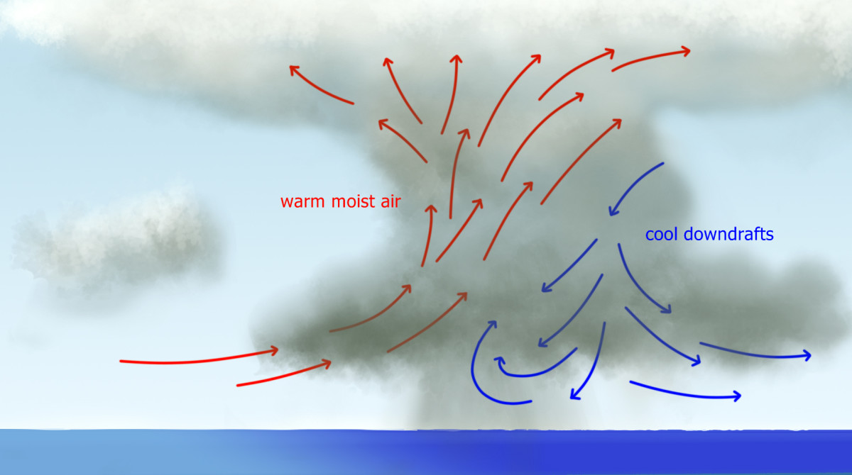
The Venturi effect is a principle in fluid dynamics that states that when a fluid (like air) is forced through a constricted space, its velocity increases while its pressure decreases. This can be observed in everyday objects like airplane wings, car carburetors, and even your garden hose.
Convergence
Divergence
Full Venturi:
Inter isand Venturi
Mountain gap Venturi
Half Venturi: Coastal Venturi Effect
The Half-Venturi Effect of Coastal Mountains on Parallel Winds
When wind blows parallel to a coastline with mountains, it can create a phenomenon similar to the Venturi effect, though not a perfect one. Here’s how it works:
The Venturi effect: This principle states that when a fluid (like air) flows through a constricting passage, its velocity increases as pressure decreases. Imagine squeezing water through a garden hose; the water flows faster at the narrow end.
Coastal mountains and wind: When wind blows parallel to a coastline with mountains, the mountains act like a partial constriction. The air isn’t forced through a narrow channel like in a true Venturi tube, but it is “guided” by the mountains, creating a funneling effect.
Increased wind speed: As the wind approaches the mountains, it has two options:
-
- Turn inland: Some air will be deflected inland, potentially creating upslope winds and turbulence.
-
- Flow along the coast: The remaining air, unable to easily escape inland, will tend to speed up as it’s “funneled” by the mountains. This is similar to the Venturi effect, although not as dramatic because the constriction isn’t complete.
Factors affecting the effect: The strength of this “half-Venturi” effect depends on several factors:
-
- Mountain height and shape: Taller and steeper mountains create a more pronounced effect.
-
- Distance between mountains and coastline: Closer mountains create a stronger effect.
-
- Wind speed and direction: Stronger winds and winds blowing directly parallel to the coast will be more affected.
Real-world examples: This phenomenon is observed in many coastal regions around the world, including:
-
- South American Coast
Opens in a new window en.wikipedia.org
Venturi effect
The Venturi effect in the between islands: The Caribbean Lesser Antilles:
The islands of the Caribbean Lesser Antilles are geographically arranged in a chain, with some islands being closer together than others. When trade winds, the prevailing easterly winds in the tropics, blow through the gaps between these islands, the Venturi effect can come into play.
As the wind encounters the narrow passages between the islands, it is forced to speed up due to the reduced space. This increase in wind speed can lead to several interesting phenomena:
-
- Increased windsurfing and sailing opportunities: The stronger winds created by the Venturi effect can make these islands popular destinations for windsurfing and sailing enthusiasts.
-
- More powerful waves: The faster winds can also generate larger and more powerful waves, which can be attractive to surfers but also pose challenges for coastal communities.
-
- Local variations in wind speed and direction: The specific wind patterns around each island can be influenced by the unique shape and size of the surrounding islands, creating localized areas of stronger or weaker winds.
Examples of the Venturi effect in the Caribbean Lesser Antilles:
-
- The Grenadines: The Grenadines, a chain of islands between Grenada and St.Vincent, are known for their strong winds and challenging sailing conditions, which are partly due to the Venturi effect.
-
- The Guadeloupe Passage: The Guadeloupe Passage, between the islands of Guadeloupe and Dominica, is another area where the Venturi effect can create strong winds and currents.
-
- The Anegada Passage: The Anegada Passage, between the Virgin Islands and Puerto Rico, is also known for its strong winds and challenging sailing conditions.
It’s important to note that the Venturi effect is not the only factor that influences wind patterns in the Caribbean Lesser Antilles. Other factors, such as topography, local weather systems, and seasonal variations, all play a role in shaping the winds in this region.
Topographic Impact:
-
- Venturi effect: Valleys and canyons can act like Venturi tubes, accelerating wind speed as it passes
-
- through. This can create localized areas with significantly stronger winds compared to open areas.
-
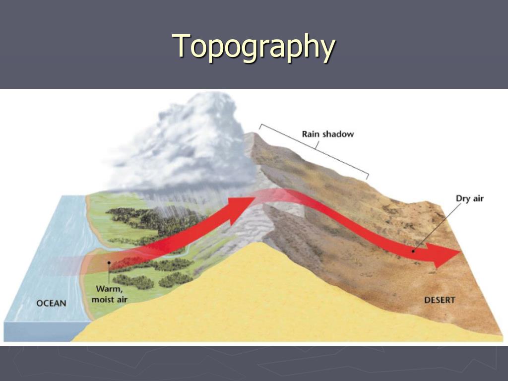
- Föhn effect: When trade winds are forced over mountains, they can descend on the leeward side as warm, dry winds, known as the Föhn effect. This can create localized areas with reduced rainfall and increased temperatures.
-
- Aspect: The orientation of an island’s slopes plays a crucial role. Windward-facing slopes experience the full force of the trade winds, while leeward slopes may be sheltered, receiving significantly less wind.
Island Examples:
Bon
-
- Bonaire
-
- Grenada: The mountainous interior creates random wind patterns. The lee western coast enjoys calmer conditions, while the windward east coast experiences stronger winds and higher rainfall.
-
- Guadeloupe: The butterfly-shaped island has two distinct regions. Grande-Terre,the flatter eastern part, has consistent trade winds, while Basse-Terre, the mountainous western part, has more variable wind patterns and increased rainfall on its windward slopes.
-
- St. Vincent and the Grenadines: The Grenadines, a chain of smaller islands south of St. Vincent, experience stronger and more consistent trade winds due to their smaller size and less complex topography.
Additional factors:
Squalls
-
- Ocean currents: Warm ocean currents can intensify trade winds, while cooler currents can weaken them.
-
- Local weather systems: Tropical storms and hurricanes can significantly disrupt trade wind patterns, bringing strong winds and heavy rain.
Resources:
-
- National Oceanic and Atmospheric Administration (NOAA): https://www.noaa.gov/
-
- Caribbean Weather Center:https://www.nhc.noaa.gov/marine/forecast/enhanced_carib.php
-
- Tropical Meteorology Project: https://bmcnoldy.earth.miami.edu/tropics/sectors/
-
- Mountains and hills: The presence of mountains and hills can channel and amplify trade winds, creating localized areas of stronger winds. For example, the mountainous islands of Dominica and St. Lucia experience stronger trade winds on their eastern sides, while the sheltered western sides have calmer conditions.
-
- Valleys and plains: Valleys and plains can funnel and accelerate trade winds, leading to stronger gusts. Conversely, they can also create areas of reduced wind speed due to sheltering effects.
-
- Island size and shape: Smaller islands generally experience more consistent trade winds, while larger islands may have more varied wind patterns due to their complex topography.
Interaction between topography and trade winds:
-
- Increased rainfall: The combined effect of trade winds and mountainous terrain can lead to increased rainfall on windward-facing slopes, creating lush vegetation and rainforests.
-
- Coastal erosion: Strong trade winds can contribute to coastal erosion, particularly on exposed shorelines.
-
- Sailing and surfing: The diverse wind patterns created by the interaction of topography and trade winds make the Caribbean a popular destination for sailing and surfing, with different islands offering a variety of windsurfing experiences.
Here are some examples of how specific Caribbean islands are affected by the interaction of topography and trade winds:
-
- Barbados: This relatively flat island experiences consistent trade winds, making it a popular destination for windsurfing and sailing.
-
- St. Lucia: The mountainous terrain of St. Lucia creates localized areas of stronger winds, particularly on the eastern side. The Pitons, two volcanic plugs, also create unique wind patterns around the island.
-
- Dominica: The mountainous interior of Dominica channels and amplifies trade winds, making it one of the windiest islands in the Caribbean
Future blogs in this series will talk about:
-
- Seasonal variations in the Trade Winds
-
- The first humans to use the Caribbean Trade Winds.
-
- Island topography and Trade Wind strength
-
- The Trade Winds and island climates
-
- Ocean currents and topography
-
- Local currents and wind direction and strength.
-
- Street clouds and Trade winds.
-
- Hurricane paths and the Caribbean trade winds
-
- Gulf of Tehuantepec gale force winds and the Caribbean Trade Winds
-
- Why the trade winds often blow all night.
-
- Why Bonaire is a windsurfing, kiteboarding and winging mecca.
-
- Why Lac Bay on and Atlantis Beach on Bonaire are so windy.
-
- What shapes the Bonaire water currents that impact SCUBA divers.
-
- Where does all that air from the Trade Winds go?