Once San Francisco had more summer time fog and extremely steady winds. In recent decades the
winds are often more turbulent and fog is less widespread.
This same pattern is becoming more frequent in Southern California and in the Columbia River Gorge. This change has been reported in many places.
Here are examples in a pop article and a scientific journal.
If you like to delve into the science behind this go to the bottom of the above article, click on references and see how different science seems vs political blogs.
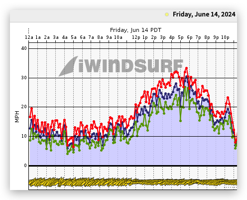
Covering this change even superficially would take a series of blogs. So in this blog I am going to cover just the increasing wind turbulence and diminished fog at one location: Crissy Field near the Golden Gate Bridge.
Proximal Causation
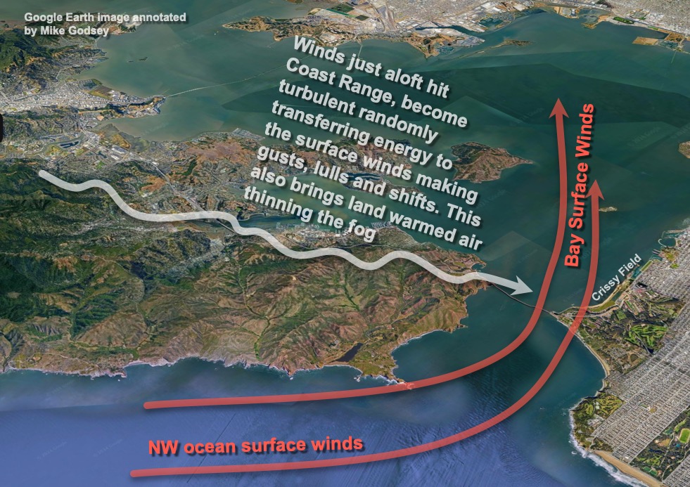
At the local level the cause of this Crissy Field turbulence is the interaction of the steady cool stable WSW winds at the surface versus the warmer unstable NNW winds hitting the Coast Range and rippling overhead.
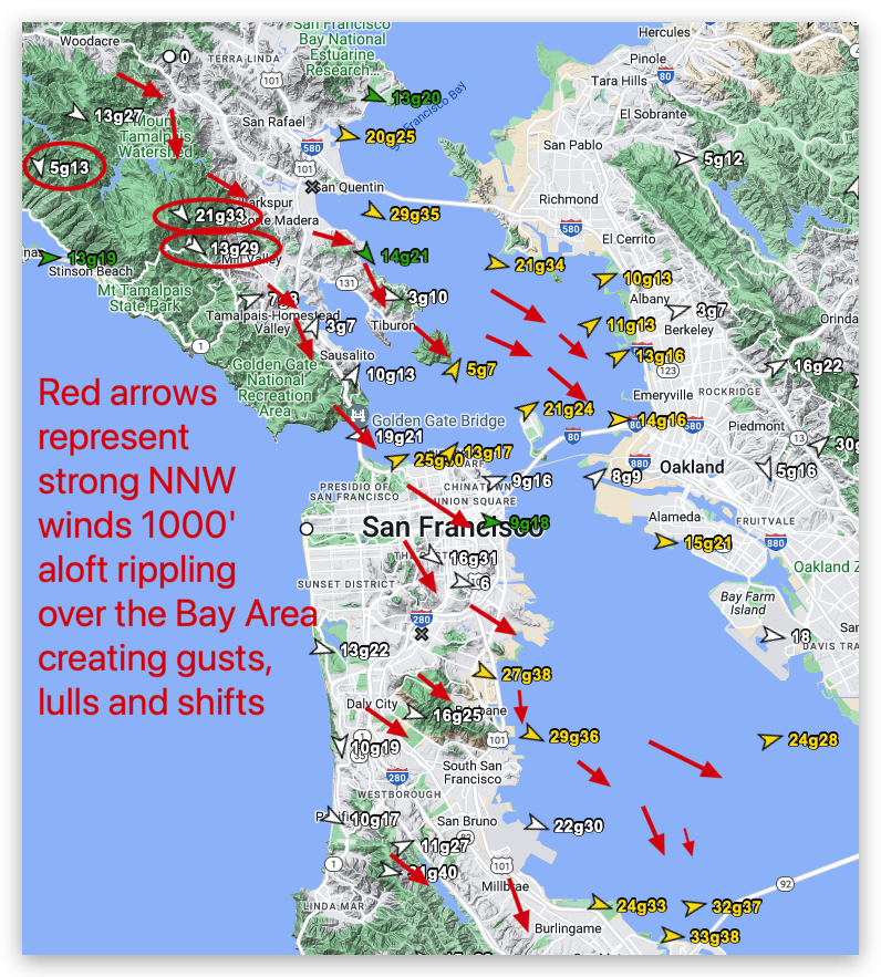
This first graphic shows this interaction. Crissy is especially prone to this turbulence the Marin County topography upstream is exceptionally high, complex and hot.
This wind San Francisco for June 16, 2024 has red arrow and oval representing this strong NNW winds ≈ 1000 feet aloft (975 MB).
Notice how this flow makes the surface winds much stronger at some sites while it disrupts the winds at other sites like Pt. Isabel and Berkeley.
Ultimate Causation
So why are these NNW winds ≈ 1000 feet aloft (975 MB) or higher becoming more common?
The huge summertime North Pacific High resides between Hawaii and the USA west coast. This high-pressure helps create the NW ocean winds that are common on the west coast from March into September. It is common for the NPH to extend a lobe of high-pressure known as a ridge
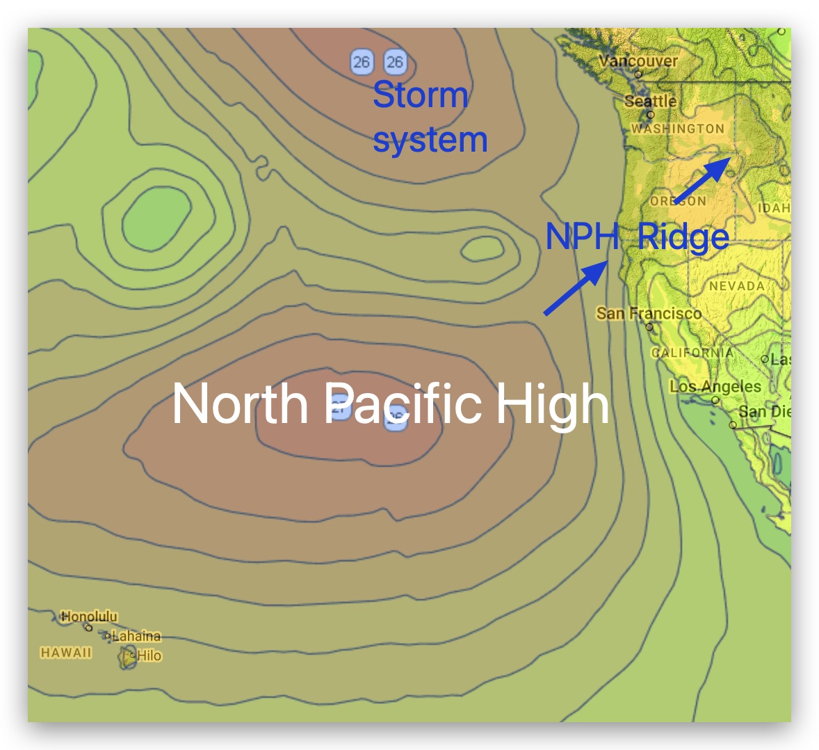
towards the Pacific Northwest. This is one reason the Oregon coast has mostly summer North winds rather than California’s NW winds.
However in recent decades the North Pacific High increasingly pushes ridges much further into the Pacific Northwest and even northern California. So while there are commonly NW surface winds near San Francisco this ridge causes NNW winds just aloft.
This animation shows the NPH’s isobars roughly parallel to the San Francisco coast. This pressure gradient creates the surface NW winds.
Note how the surface isobars kink into far Northern California and into the Pacific Northwest form the ridge.
Also, note how this causes NNW winds to develop aloft over the ocean and the San Francisco Bay Area. Since, the NW wind is passing over a chilly ocean its air is cool and dense (Stable air in meteorology jargon) so it tends to stick to the surface making for steady winds.
But as the winds just aloft hit the sun baked Coast Range they heat and become unstable and turbulent. Sometimes this turbulence reaches the surface producing wind shifts, gusts and lulls.
Of course the real question is… what is the ultimate cause of this increased frequency of NPH ridges. And that has to do with a warming Arctic.