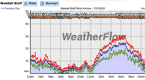
We are all used to seeing random gusts and lulls in the kite and windsurf wind graphs. This gives the wind graph a a jagged appearance. On good days the jags are small on bads days they are huge
This first image shows a typical random wind pattern at Waddell on Thursday, July 31.
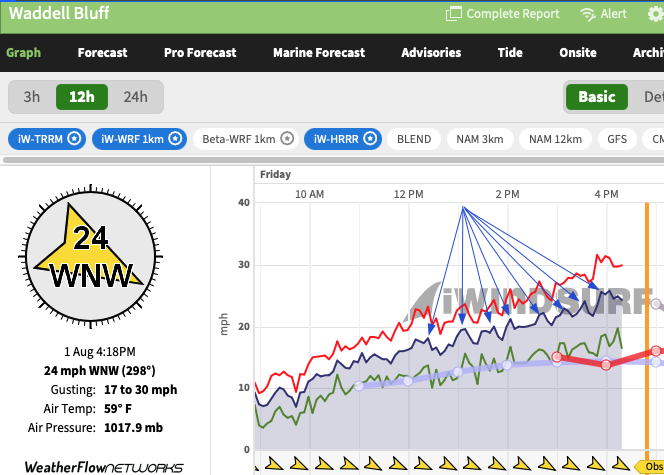
But the Friday, August 4 windgraph does not look very random. The blue arrows show the wind going smothly up and down llike it was following a rhythm.
This rhythm in the sensor winds is likely result of Atmospheric Gravity Waves.
Atmospheric Gravity Waves. When you see lines or ripples (often called “wave clouds”) in the marine layer over the San Francisco Bay Area on satellite imagery, these are typically caused by atmospheric gravity waves.
Causation: These are oscillations that develop when stable air is pushed upward (in this case by the Coast Range just north of Año Nuevo), then sinks back and overshoots, creating a repeating up-and-down motion. This is common when there’s a strong marine layer and stable stratification with robust northwesterly surface winds, which are typical near the Bay Area coast.
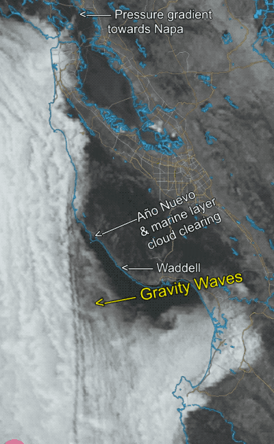
In this satellite animation from fog today, you can see the Gravity Waves standing in position over the marine layer clouds near Waddell.
In these setups, the gravity waves in the marine layer have several key effects on surface winds when strong northwest (NW) ocean winds are present:
Surface Wind Fluctuations: Gravity waves transfer a bit of momentum to the surface winds due to friction. This leads to periodic strengthening and weakening of the surface wind as the crests and troughs pass. So, even with generally strong NW flow, winds at the surface can gust up and down in sync with the wave pattern.
Where the air is rising (in the wave crest), surface pressures can decrease slightly, speeding up the wind locally, while the sinking (wave trough) can slow it or even cause brief lulls.
Gustiness and Turbulence: The interaction of strong NW winds with the gravity waves can make the wind gustier and more turbulent. Wind observers may notice rapid swings in wind speed over short distances and times due to this wave-induced turbulence.
Local Wind Shifts: Wave patterns can cause surface winds to shift direction slightly, depending on their phase. For example, NW winds may veer more westerly or even temporarily back toward the south as air parcels oscillate horizontally along with the wave motion.
Impact on Marine Layer Structure: The upward and downward motions of gravity waves modulate the thickness and density of the marine layer, potentially bringing brief clearing (“holes” in the cloud deck) or thickening (patches of denser, lower cloud).
Summary: when these gravity wave lines are visible, expect gusty and variable surface winds even under a persistently strong NW ocean wind regime, along with localized accelerations and brief lulls aligned with the wave crests and troughs. These features are also direct indicators of atmospheric turbulence, which pilots and wind sports enthusiasts often notice in such conditions