 Upper convergence and divergence the strength of the North Pacific High:
by Mike Godsey, mikeATiwindsurf.com
ROUGH DRAFT
There is a tendency of many kiters and especially sailors to look at the wind from a 2-dimensional perspective. This means we only care about the direction and strength of the wind. Although kiters are sometimes aware that their kite is feeling winds that they are not feeling at the surface especially in gusty conditions.
Likewise, we are sometimes shocked when our airline flight time is much shorter or longer than the miles alone would predict. And if you live in the mountains you sometimes see evidence in clouds like the lenticular clouds in my banner and the image just above that there are powerful winds aloft even when it is nearly calm at the surface.
In our forecasts, we sometimes mention in passing upper-level winds or upper troughs and ridges but it is hard for us to connect these events to your surface winds in a single paragraph. So let’s take a more detailed geeky look at how those upper-level winds impact the high pressure and low pressures that often deliver our wind.
Simplified Upper-level Convergence and Divergence aloft in a simple 3D image:
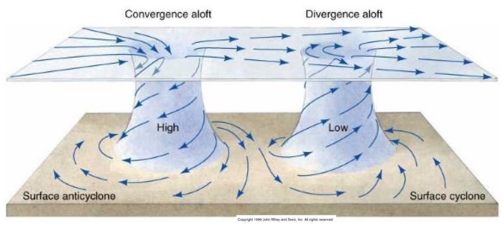
First, let’s show you a very simple 3D graphic of what convergence and divergence look like relative to surface high pressure and low pressure.
At the top of the image we are looking at the winds at about ≈ 18,000 ft. On the left side we are seeing Convergence of those winds. This makes the air more dense in this area so it sinks towards the surface augmenting the surface high pressure (Anticyclone).
On the top right of the image notice how the wind aloft is fanning out creating Divergence aloft. This makes the air less dense creating an area of lower pressure. And this encourages the surface air to flow upward which makes the surface low pressure stronger.
Model output and upper-level Convergence and Divergence in 3D image:
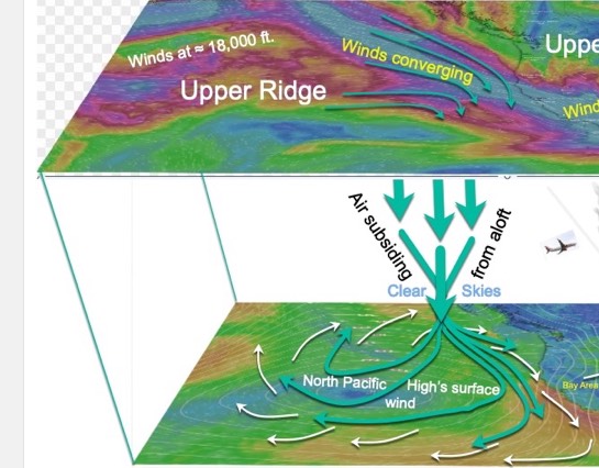
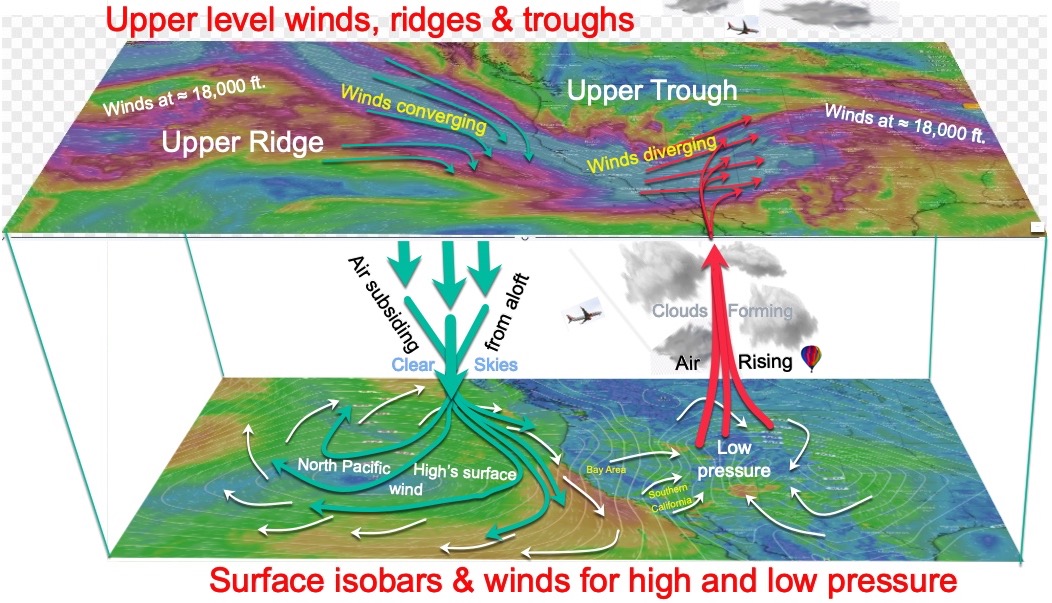
At the bottom of this 3D image for next Tuesday, April 9 and find the North Pacific High with its isobars compacted against the California coast. When the isobars are tightly spaced like this there is a strong pressure gradient on the coast so the NW accelerates. Note that there is also low pressure in the Great Basin and beyond which also contributes a pressure gradient that helps pull the wind down the coast and inland. Clearly, this is a very windy pattern for Northern California and perhaps Southern California. This is the sort of setup we will probably describe in our forecast next Tuesday.
Now let’s look at the back story why the North Pacific High is so strong next Tuesday and the Great Basin has such low pressure. Looking at the top part of the 3D image above notice the upper-level winds at ≈ 18,000 ft. The northward wind pattern is called an upper ridge while the southward pattern is called an upper trough. These are very strong winds that sometimes are over 100 mph.
Notice how these bands of upper-level winds are sort of like a river. In some location the wind band is wide and other locations it is narrow. For this to happen there has to be locations where the winds are converging like a river narrowing and other location where the winds are diverging like a river widening.
Remember that all the colored wind patterns are up at ≈ 18,000 ft. Now find the upper-level ridge and note how the upper winds approaching California are converging above the North Pacific High at the surface.
Now visualize all those rushing air molecules cramming into this zone. This will make the air over this region denser and since it is heavier it will sink in the atmosphere. This creates stronger high pressure along our coast. And as this air sinks it carries some of its motion towards the surface enhancing the North Pacific High’s surface NW winds.
Now check out what is happening over the Great Basin. The upper-level winds in that zone are fanning out or diverging. This means the rushing air molecules are further apart creating lower pressure aloft. And this, in turn, enhances the surface low pressure in the Great Basin.
This lower pressure creates a pressure gradient from the North Pacific High to the Great Basin strengthen the surface NW wind and encouraging it to move inland.
Since these upper ridges and upper troughs normally move from west to east the zones of convergence and divergence will shift eastward and the North Pacific High’s surface NW winds should weaken of following days.


