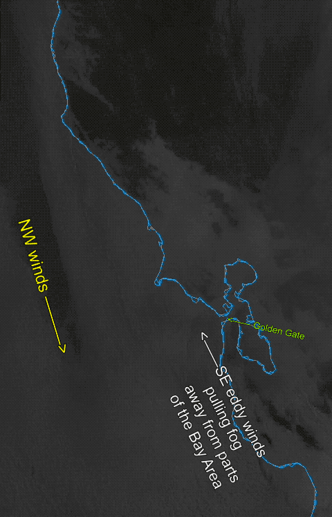
The eddy off the Golden Gate is larger than when I issued my forecast, so we are seeing early, faster clearing due to the eddy’s SE winds. Despite that I am sticking to my current forecast due to the strong NW winds out past the Farallon Islands (18 miles west Gate).
7:30 AM forecast:
A larger than expected counter-clockwise eddy has spun up overnight with support up to 5000 feet aloft. This has created southerly coast winds from Half Moon Bay to Bodega while SW winds inside the Bay have thrust fog over the Bay with streamers into the Central Valley.
Unless the eddies winds turn from SW to SE slow clearing may stop many sites from reaching their forecast wind potential, so watch your window and the satellite imagery. If the eddy dies as modeled the ocean winds turn WEST. These WEST winds will hold a broad streamer of fog through the Golden Gate to near or over the East Bay shore.
All this means: 1. Unreliable Crissy/TI winds inside. 2. Probably only mild winds inside for Pt. Isabel, Race Track and Berkeley due to fog. 3. Mild AM winds and stronger PM winds for Sherman Island. 4. Weak W to WNW winds for Coyote and 3rd except east of the channel and poor launch sites winds. 5. Good Westerly winds from Stick to Flying Tigers/Haskins. 6. Mid to upper-teens winds from Waddell and stronger at Natural Bridges if and only if we get the late Año Nuevo clearing.