by Matt Sounders & Mike Godsey
You may have noticed that the weather has gone a bit bonkers this year for much of the west coast. And, no, you’re not alone in having this impression since the data backs up your impression. And, no, it is not Global Weirding, at least not directly.
This year the Gorge had snow on the ground for almost a month in late winter. Then it had a crazy long May heat wave. Then unending mid 30’s wind in June. And currently a long period of weird clouds and wind.
In the San Francisco Bay Area we have seen long periods of eddies and southerly winds along the Bay Area coast with the beloved NW winds AWOL. The frequent southerly flow has been a delight for kiters and windsurfers at Bay sites north of the Bay Bridge. But for Crissy, the coast and much of the Peninsula it has been a wind drought.
So what is behind all this Gorge and San Francisco weirdness? Blame El-Nino!
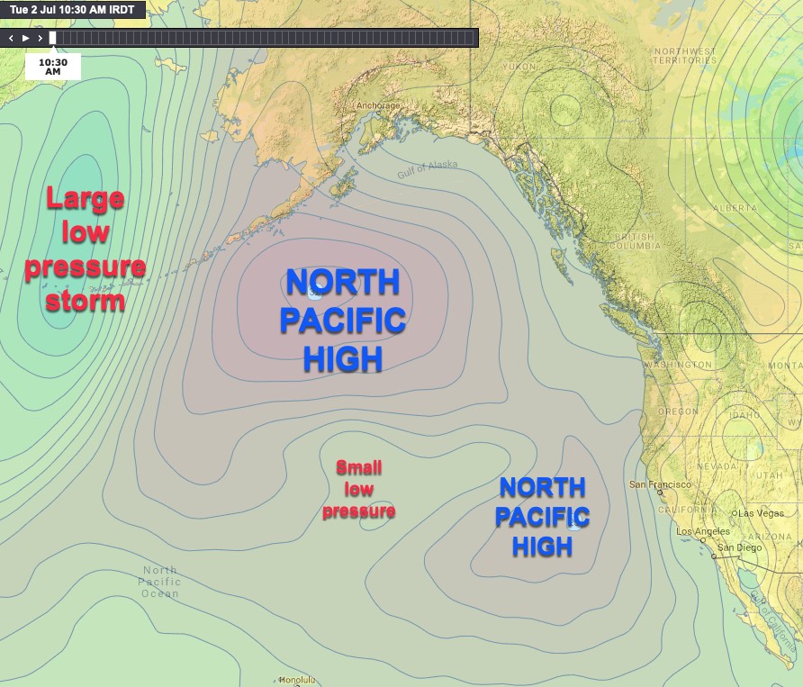
You may have noticed that it is a weird summer with the wind cycling between WSW eddy wind and, more rarely, out of season very strong NW ocean wind. Why? El Nino has enhanced Pacific ocean warming towards the Artic. Such warmth encourages a larger elongated North Pacific High to span the waters from west of Hawaii into Alaska to the tip of Baja. <b>In normal years the North Pacific High develops an inland kink over the Pacific Northwest as systems pass to the north which makes the Gorge blow. But in an El Nino year, the average storm track is further south. This makes the high pressure kink over far Northern California. And as you can read below…. this leads to an eddy.</b>
Every few years, the El Nino-Southern Oscillation – a warming of tropical Pacific sea-surface temperatures linked to a slowing or even reversal of the normally easterly trade winds – begins. El Nino is tied to a host of changes to the normal climate of the west coast. If you live in California you know that a strong El Nino brought more rain than normal to California this winter.
However, El Nino’s effects in the summer are not as well understood, but, this year, we are seeing a doosy. El Nino increases westerly winds south of the North Pacific High. Those west winds have often been stretching the North Pacific High north and sout . That is why the forecast has sometimes noted that the NPH stretched up to the Gulf of Alaska. Those El Nino westerly winds have sometimes crippled the North Pacific High southern flank disrupting Hawaii’s trade winds. [this would be a good place to show a figure from the last couple of days with the hilariously northward displaced NPH with its sad southern flank under attack by a subtropical lows.
To read about how this has impacted the Gorge click here.
In the San Francisco Bay Area the distorted NPH is doing several things.
First, it’s weakening northerly winds at the coast as pieces of the NPH are pushed east onto shore.
Second, it’s creating an opening for unusually sharp upper-level troughs to pass through the region which keeps temperatures far cooler than normal and changes the nature of marine layer clouds in the Corridor, giving them more height and picking them up off the floor of the Gorge.
Third, those same upper troughs have limited the heating of the waters flowing into the Columbia hence the cool waters for the July 4 holiday.
Fourth, it’s keeping surface pressure gradients unusually strong in the Near and Far East, making for many windy days at a time of year when that should become rarer.
Fifth, finally, it’s displacing the Columbia Basin low east of its normal hangout, causing winds just above the eastern Gorge to, more often, come from the WNW, rather than the WSW – this is making Maryhill and The Wall often weak at the launch sites while enhancing Rufus winds.

