In response to significant long-term climatic shifts, the National Weather Service (NWS) has updated its public notification protocols for temperature hazards in Alaska.
Climatological data reveal that Alaska is experiencing anomalous warming at a rate approximately double that of the contiguous 48 states, with a recorded increase in the statewide average annual air temperature of 1.67°C (3°F) over the last 60 years.
This warming trend has necessitated a procedural shift within the National Weather Service (NWS).
This is a previously unused alert category in the state.
Historically, NWS officials relied exclusively on Special Weather Statements to inform the public of potentially hazardous thermal conditions since such events used to be less common.
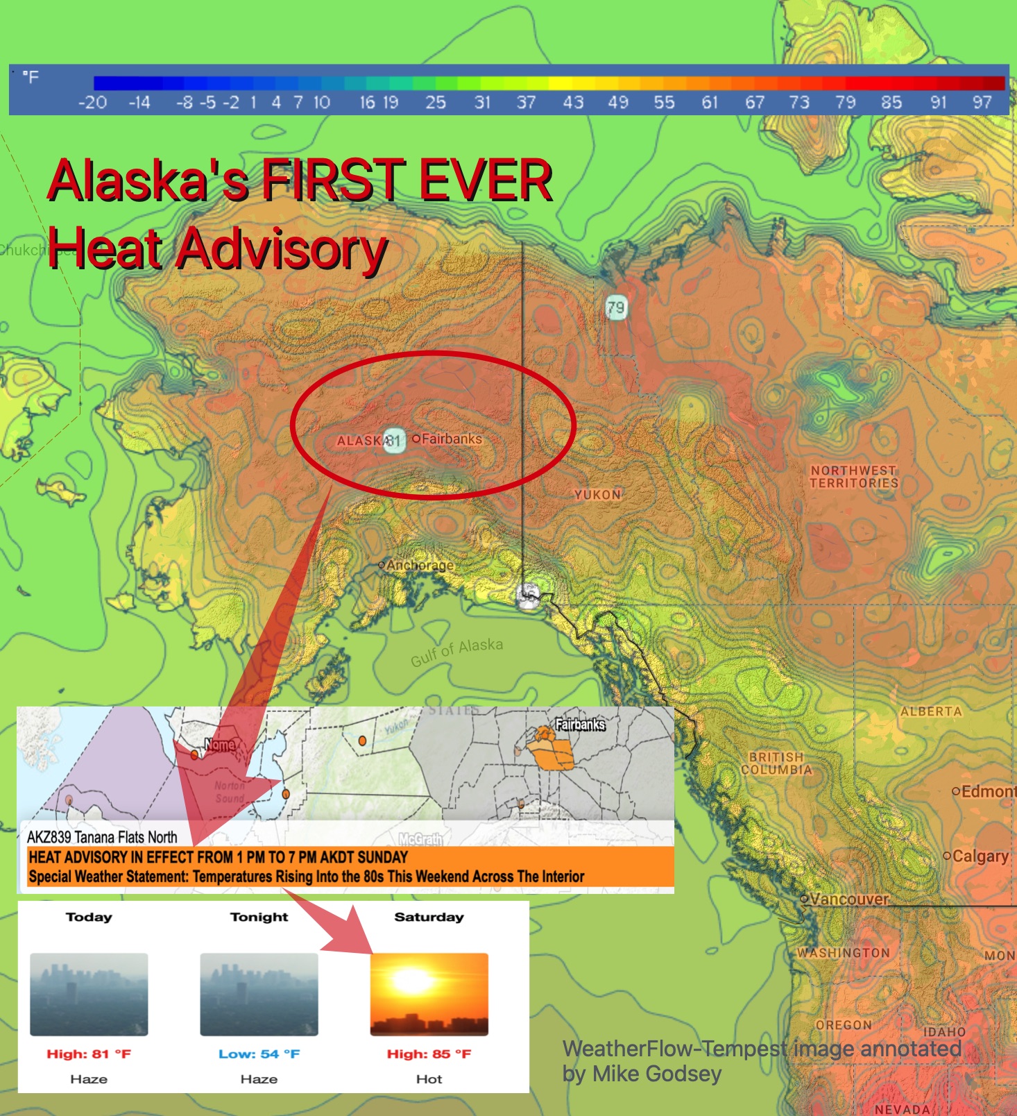
The first operational application of this new protocol occurred on Thursday, June 12, when the Fairbanks NWS office issued a heat advisory, marking the first time such a bulletin has been required for the region.
This event signifies a notable meteorological occurrence partially driven by sustained regional climate change.
NWS’s Alaska Region Headquarters, posted on Bluesky. “Every place is built for its climate. Alaskan houses are built to retain heat and do not have air conditioning.” If having a Heat Advisory for temperatures of 85F seems strange… well the NWS went on to say: “As Alaskans, we do not pass judgment on Lower 48 places that shut down with inches of snow.”
Prolonged spells of high temperatures are becoming more common in Alaska. In July 2024, the temperature in Fairbanks hit 90 degrees Fahrenheit, setting an all-time record high for Alaska. highest temperature ever recorded on that date in Alaska.
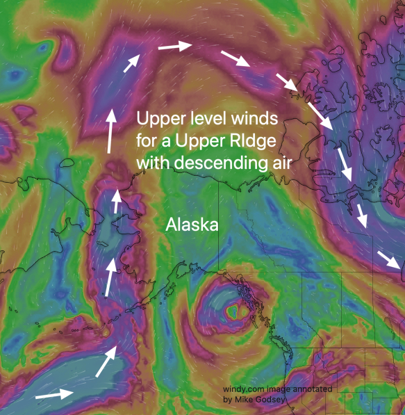
While climate change is a contributing factor to the long-term temperature increases, it is upper-level weather factors that are triggering this particular heat event.
Cause of the heatwave
Meteorologically speaking, the immediate cause of the heatwave expected to bring 85-degree temperatures to Fairbanks is the formation and strengthening of a significant upper-level ridge of high pressure over Interior Alaska.
This atmospheric feature is essentially a large northward bulge in the jet stream. This creates a dome of high pressure in the middle and upper levels of the troposphere (roughly 10,000-30,000 feet). Here is how this ridge directly translates to a surface heatwave:
1. Subsidence and compressional heating
Above Alaska this weekend is a high-pressure upper ridge up at ≈ 18,000 feet aloft (500 MB). This is an area of large-scale sinking air, a process known as subsidence. As air from the upper atmosphere sinks, it compresses the air, causing warming. This process, called compressional heating), is the primary mechanism generating the unusually hot air mass. For every kilometer the air descends, it can warm by approximately 10°C (18°F) if the air is dry.
2. Creation of a “Heat Dome”

The sinking air within the ridge acts as a cap on the atmosphere. This has two major effects:
- It prevents convection: The stable layer of sinking warm air suppresses the vertical motion needed for clouds to form and for cooler air to rise from the surface. This leads to clear, sunny skies, maximizing the amount of direct solar radiation (insolation) that reaches and heats the ground.2
- It traps heat: The ridge functions like a lid on a pot, trapping the hot air at low levels and preventing it from escaping. This allows surface temperatures to continue building day after day.
3. Weakening of Surface Winds
Inside the core of this strong high-pressure system, surface winds are typically light and variable. The lack of stronger winds prevents the mixing of cooler air from surrounding regions, allowing the locally generated heat to become more concentrated and intense.
In summary, the forecast for Fairbanks aligns perfectly with a classic heat dome event. A strong and stationary upper-level ridge is causing air to sink, heat up through compression, and remain trapped under clear, sunny skies. This combination of powerful atmospheric dynamics is the direct cause of the significant and unseasonably warm temperatures expected this Saturday.
This type of major northward excursion of the upper-level winds is becoming more common worldwide.
This upper ridge has also locked a huge North Pacific High in position. So its isobars have been compressed against the Northern California coast for many weeks. This maintains strong northwest winds on the coast and, more importantly, causes very strong winds to develop just aloft over parts of the Bay Area. These winds aloft cause waves in the marine layer clouds, and when they descend to the surface, you feel massive gusts.