Hello, weather Fans! With another area of tropical development, blossoming rather quickly you might say, we will see some rain and gusty winds for the Carolinas, mid-Atlantic, and Northeast. This Low is not exactly a tropical storm, however, it may have some tropical storm characteristics. We have been looking at this particular area of development for a few days and things are ramping up. NWS first titled it as a potential tropical cyclone 16. Now tropical storm Ophelia Friday afternoon. In this blog, we will discuss how this cyclone got its start, warning/impacts, as well as the difference between non-tropical storms, tropical and subtropical.
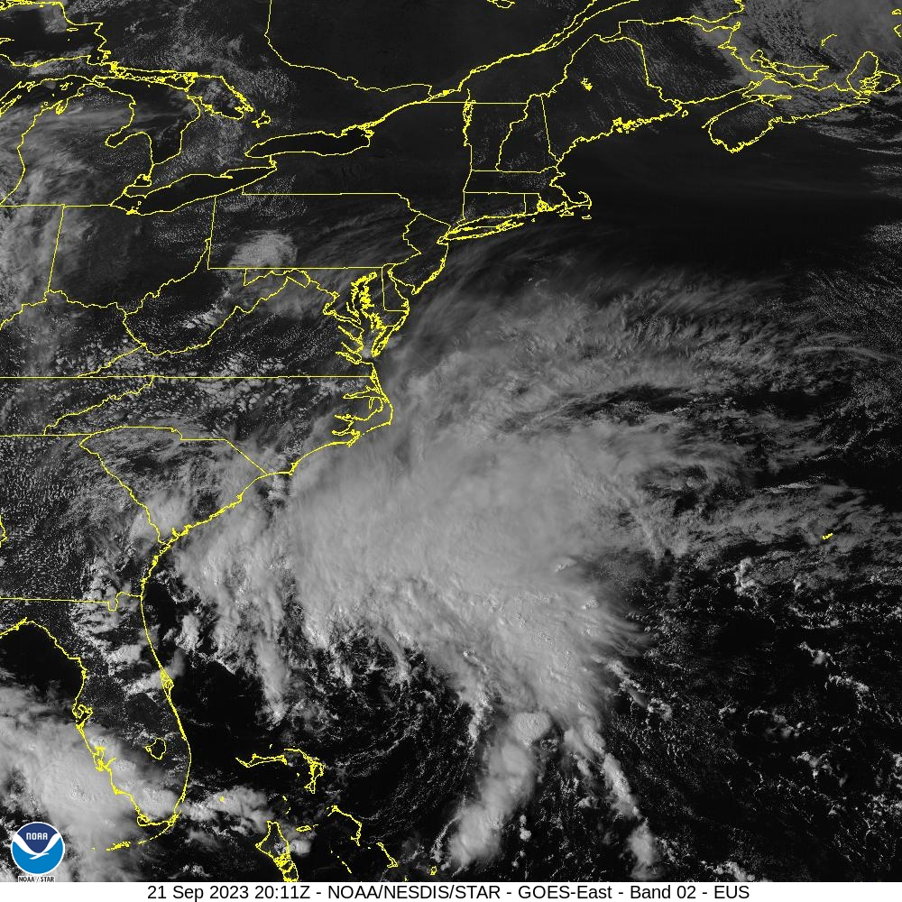
This storm looks to continue to develop over the next couple of days. Models are coming into agreement as the low strengths. The strongest winds along NE North Carolina and Southeast Virginia will be Friday evening into Saturday morning, N-NE 25-35 kts with gusts N-NE 40-50 kts due to high pressure just off the coast of the northeast it will help tighten pressure gradients and winds will decrease some in the afternoon Saturday. Winds pick up Saturday night into early Sunday morning N-NNW 15-25 kts N-NNW 24-34 kts. Tropical Storm Ophelia will move northwest and will make landfall somewhere in east North Carolina near Cape Lookout. Tropical storm Ophelia may have a chance to increase into a category one hurricane, as warm water helps strengthen it and the pressure continues to drop. Ophelia’s development and track has been very uncertain and still is. Before landfall and after landfall, the track of this tropical cyclone will still have some uncertainty and adjustments may be made.
Hurricane Ophelia developed due to a stationary front just east of Florida which stalled for a few days. Then it develops into a non-tropical low. Mid-level troughing is set up over the southeast CONUS, while a ridge is to the west. An area of surface high pressure over the northeast will help Tropical Storm Ophelia head NW before it exits offshore early Saturday morning. Tropical Storm Ophelia is scheduled to make landfall somewhere near North Carolina Cape Lookout around 5 a.m. Once Ophelia makes landfall, it will begin to weaken into a tropical depression as it moves toward Southeast Virginia. Then around Saturday night, early Sunday it will transition to an extratropical cyclone.
What certain types of cyclone development are there?
Non-tropical cyclones consist of a warm and cold front. Hurricanes do not form from fronts. A non-tropical cyclone has a cooler core.
A subtropical cyclone has the characteristics of a tropical cyclone and is non-frontal. The center will have two distinct sides, dry on the left and warm and wet on the right side of the Cyclone. Typically, a subtropical storm will usually have a very large cloud base with no circulation. Heavy precipitation takes place at least 100 miles from the center.
An extratropical cyclone has a cold core at its center. We can think of an extratropical cyclone as a blizzard or, Nor’easter. Typically formed between a cold air mass and a warm air mass meets and form a front.
A tropical cyclone starts over an area of warm water and will still start off as a tropical wave. It will have a warm center, along with an area of rotating thunderstorms. To be a tropical depression, you will need winds of at least 30 kts along with circulation. When wind speeds reach 39 kt it is now a tropical storm.
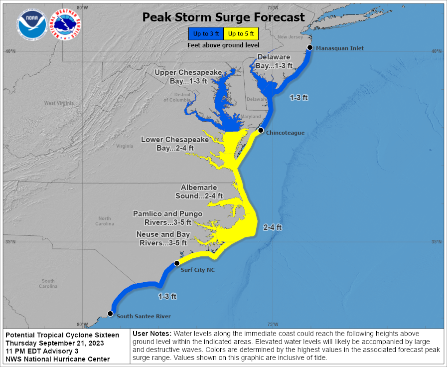
Warnings and what to expect? NWS has issued a tropical warning for eastern North Carolina and Virginia and a hurricane watch for parts of eastern North Carolina. A slight flood risk for areas extending from Northeast Carolina to Virginia 2–4 inches, and a localized 6 inches for areas further east near the Chesapeake bay and Delmarva. The highest impacts will be along the coast. Life Threatening storm surge is forecasted for eastern North Carolina and southeastern Virginia
In Conclusion, this cyclone has been a very tricky one with many uncertainties throughout the whole process. From the beginning to the end. This cyclone is a hybrid and was not formed like a normal cyclone. Nonetheless, we are looking at lots of rain and wind for the mid-Atlantic and the Northeast. As we look further into the future, there is another area of development to watch as hurricane season keeps on rolling.