Hi all, in this blog we will discuss what a backdoor cold front is. Earlier in May, a backdoor front occurred around the 3rd – 5th earlier this month. We will discuss when it usually occurs, how it forms, and more. Enjoy the read and stay tuned for more weather insights.
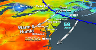
You may have heard the term “backdoor cold front” from your local TV meteorologists. This type of frontal passage usually occurs during the warmer months of spring and early summer over the Great Lakes and Northeast regions. It’s called a backdoor cold front because of its unique direction. Most common from April through June, a typical cold front moves from west to east. However, a backdoor cold front moves in the opposite direction, southward or southwestward, usually due to an area of high pressure in Canada. Sometimes it may become stagnant or move slowly. This stagnation can allow cooler air to filter in and clouds to form. This surface chart analysis illustrates how high pressure moves southwestward over the Canadian Maritimes into the Northeast region.
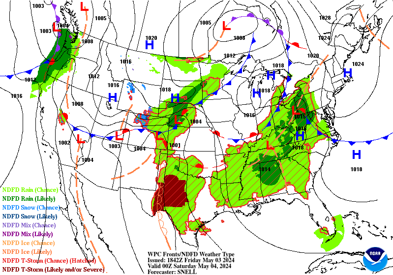
If we look at the surface chart above, we can see black lines called isobars, which are lines of equal pressure. Over Long Island, we see the number 1024. Each isobar going further northward shows increasing pressure. This indicates that surface high pressure is building, allowing the frontal passage to push even further southward. Now, let’s take a look at the temperatures below.
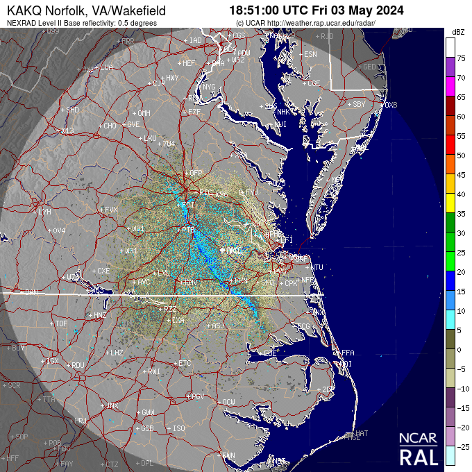
Just like in the surface analysis above, I examined the radar reflectivity provided by NCAR and observed a backdoor cold front moving east to west in central Virginia. This coincided with the time the surface analysis was issued.
What Causes a Backdoor Cold Front?
The formation of a backdoor cold front begins with a heavy, cooler Atlantic air mass and Canadian air that distributes cooler airflow southwestward. Combined with a area of high pressure over Canada, which spins clockwise, low-level wind shear occurs to the rear of the surface high pressure and pushes the cooler air further southward.
In the Northeast region, three significant factors accompany a backdoor cold front:
- A wind shift to a northerly to north-northeasterly (N to NNE) flow.
- A significant temperature gradient.
- Increased cloud cover and precipitation.
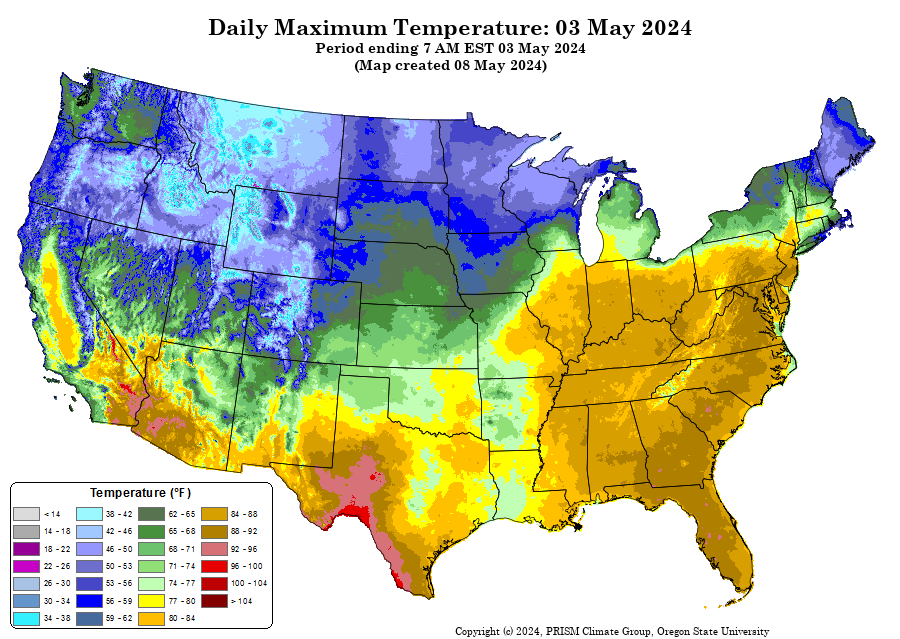
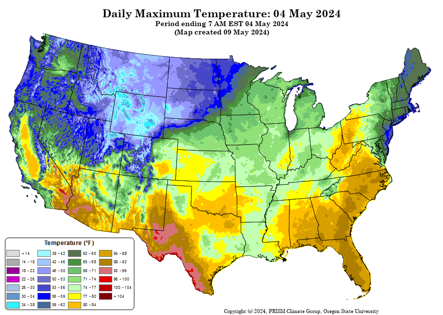
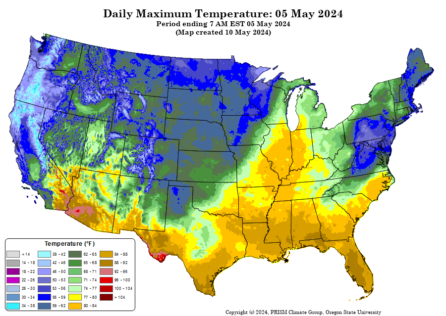
This synoptic chart analysis shows that the cold front has moved southward through the Northeast region. As the frontal passage advanced southward, winds transitioned to a northerly to north-northeasterly (NNE) flow. This wind pattern continued for the next two days. There was also a noticeable difference in temperatures. According to data provided by the Prism Climate Group, there is a significant decrease in mean daytime temperatures, typically between 15-20 degrees Fahrenheit. This stark temperature difference is evident as the frontal boundary moves southward.
As cooler air moves southward, it can linger for a few days and continue further southward due to the geographical influence of the Rocky Mountains, which can facilitate the movement of cold air.
In conclusion, a backdoor cold front forms due to an anticyclone and drives cooler air over the northeast regions. This typically occurs in the spring, around May, as it did once again this year. Similar to a regular cold front, but angled in the opposite direction, the winds associated with a backdoor cold front can change direction. Understanding what a backdoor cold front is and when it will occur is important for predicting and preparing for rapid weather changes.