Forecasters cringe.
by Mike Godsey
As you read my forecast for 7 AM this morning you are also probably cringing both at its length and all the weasel words. Well here is my excuse:
Different models have different resolution, different parameters and approach the physics of the atmosphere from different perspectives. So when it comes to sometime as ephemeral as wind they often bicker about the forecast winds.
But almost always you can look at all the real time empirical variables like satellite imagery, sensors, weather balloon data, radar, cams etc. and infer which model is more accurate on a given day.
But some days, like today the models are extremely divergent about the wind strength and distribution in the afternoon yet they are all forecasting the same AM wind pattern.
That is the case today in the Bay Area. Two of the most useful high rez. models, the HRRR and the WRAMS are forecasting clouds and SW flow in the morning with strong NW winds at the ocean buoys and a eddy like circulation around the Golden Gate creating SW flow.
But for this afternoon they have radically different forecasts.
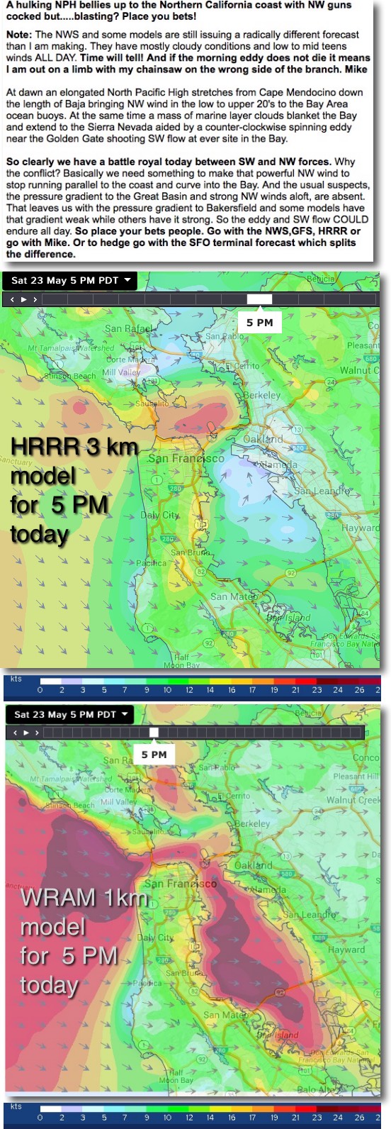
Looking at the anemic upper image for 5 PM you can see that the HRRR model has almost no wind forecast for the Peninsula and Waddell with the upper teens to 20 wind outside at Crissy and barely making Berkeley. And the coast stays cloudy and windless.
Now look at the bloody lower image showing the 5 PM WRAMS forecast. This model is forecasting upper teens to mid 20’s wind in the Bodega to near Treasure Island to 3rd. triangle with Waddell also seeing at least upper teens to 20 wind.
These are both great models but they can’t both be right.
So I was up at 4AM this morning looking at every bit of empirical data to see which model is supported by the data. All the sensor data from our sensors and the ridge top sensors were showing SW flow and smothered the Bay Area and extended to the Sierra. All of which supports the limp wrist HRRR and NWS forecast.
However subtle details of the satellite imagery led me to go with a stronger wind forecast more in line with the WRAMS.
So here I am at 9:45 AM still pouring over the data to see which way the wind is blowing for my 11:30 AM forecast.
Special Update Issued at: 5/23 10:06 AM Lots of weasel words in the forecast today. This blog tells the back story: When models bicker!
Now at 10AM I am sticking my neck out and staying with the current forecast. Why? 1. An eddy has formed from Berkeley to Larkspur which is a sign of NW wind over the Marin coast range. 2. the Golden Gate eddy seems to be shrinking. 3. The fog offshore is being shredded by NW winds. 4. I am seeing a faint hint of Año Nuevo clearing. 5. Half Moon Bay and Waddell have turned NW. There are all signs of increasing NW flow. But be aware that all the other sensors are still showing SW flow even on all the hilltops. Last call for bets!
