By Weatherflow Meteorologist Kerry Anderson
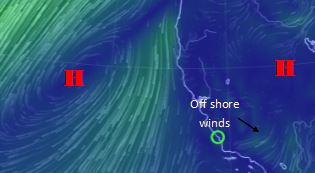
California had a taste of fall this weekend as a Northern Pacific Low made a quick dip into the area. This ended the firm grip that the subtropical High has had on the area. Or has it? Actually the above map is the forecast streamlines for Thursday showing High Pressure again building north and west of us. A strong ridge will take hold once again on the region and last through to next week. So instead of feeling like fall it will once again be hot. But also notice that with the orientation of the High to the north we have an offshore flow setting up for Southern California. So even though it will be warm and the temperature gradients will be strong the offshore flow won’t enhance the afternoon onshore sea breezes.
