Tomorrow, September 4, 2026, the upper level low begins to cut off from the main flow. We often talk about cut off lows, so I thought I’d put out an image of an example. When the upper level low (at around 500 mb) is cut off, it tends to wobble around, becoming hard to forecast…
This morning, smoke cleared out of the Western Gorge except right in Hood River and through the Hood River valley. Although there are many fires currently Western North America, the one directly affecting us here in the Gorge is from the Grasshopper Fire just east of Mt. Hood. The smoke from that fire is mostly…
Check out this image from earlier this morning. We are seeing 3 different layers of particulates and clouds. There are convective clouds south of Vancouver Island, in very white. Then marine clouds are nice beige, as they are lower in the atmosphere. And finally there’s smoke, in brown.
The stretch of river from Maryhill to Rufus is very tricky to predict and can change several times throughout the day. There are two main causes for what could look like a great day out east to not materialize. One is that just a few degrees of wind angle is the difference between a great…
Tides and currents are two reasons that Sherman Island gets so much action for wind sports in the summer months. But did you ever stop to consider what exactly is happening? When the tide is going down, or ebbing, and water flows towards the Pacific Ocean, from the Central Valley and the Sierra Nevada, it…
Strong high pressure in the NW along with deep thermal low pressure in SoCal and Nevada created a battle ground of wind directions at the Delta yesterday, Day started with W winds and switched to N in a matter of minutes with strong winds from both directions that overlapped.
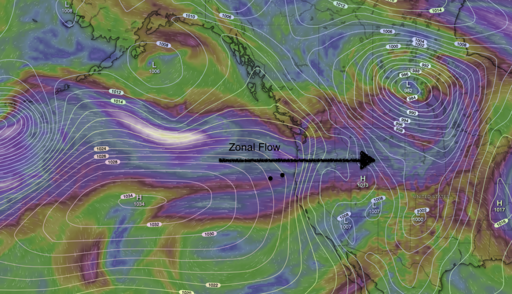
The image above depicts winds in the upper atmosphere. When upper level winds, at about 15,000 ft are blowing directly from the west in a straight-ish line, it is said to be Zonal. Often, a surface low pressure will be ahead, on the leading edge, and another surface low pressure on the trailing edge. This…
When forecasters use the terms “cut off low,” we are referring to a smaller, trough or low pressure in the upper atmosphere that is not part of the larger and main flow. Notice in this image and outline in red there is a larger flow of the upper level winds? Below, there is a smaller…
When looking at gradients in the Gorge, we often look for a thermal low, connected to the Great Basin, which often sits in the Columbia Plateau most of the summer. But in Spring, when upper level lows are present, a surface low pressure gets created out ahead, under the highest Differential Potential Vorticity Advection (DPVA)….