For the Charleston maritimes and along the cooler shelf waters, the sea surface temps are currently at ~52.2°, which remains very chilly after an elongated period of cold weather. It got down to 44° as the lowest recording back on Feb 2nd, 2026 right after our snow event. It has since rebounded and is close…
Here is a vlog I did to talk about some of the basics in wind. Enjoy!
By Meteorologist Shea Gibson on 9/15/21 On Monday night, Tropical Storm Nicholas was close to making landfall along the Texas coast after a journey from the Bay of Campeche. It quickly gained strength through the day and we started seeing hurricane force gusts at a few of our stations near dusk. As the core of…
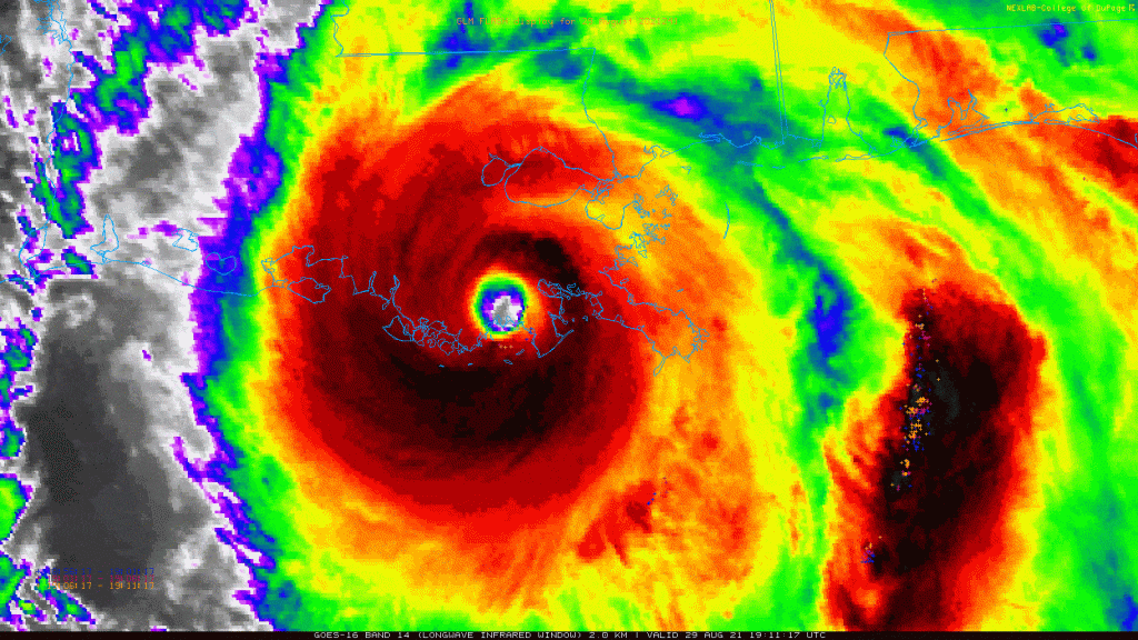
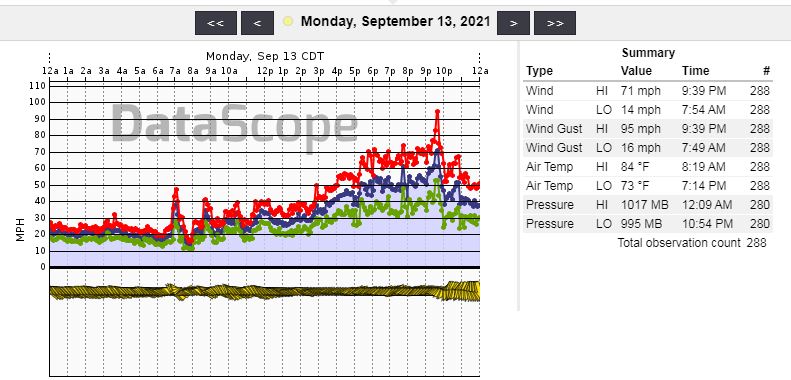
By WeatherFlow meteorologist Shea Gibson on 8/29/21 On the 16th anniversary of Hurricane Katrina (2005), we had another land-falling system named Hurricane Ida that was even stronger than Katrina at a strong CAT 4 with winds of 150mph at the time of landfall. This system steadily developed in the Caribbean during this past week and…
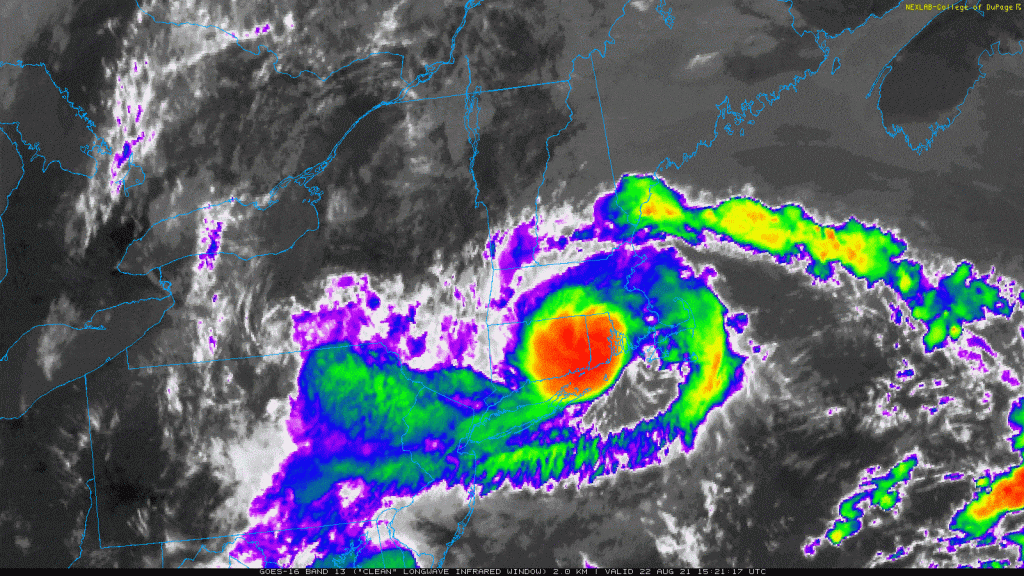
By WeatherFlow meteorologist Shea Gibson on Sunday, 8/22/2021. We had a rather rare event happen as Tropical Storm Henri made landfall at ~12:15PM ET near Westerly, Rhode Island with winds of 60mph. Several spots gusted to 69 and 70mph as recorded within our own Weatherflow sensors, for which the NHC referenced quite a bit in…
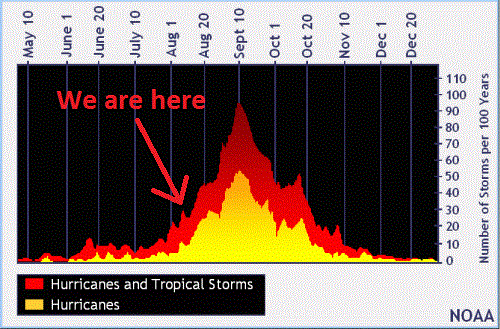
By WeatherFlow Meteorologist Shea Gibson 8 Aug 2021 – We are predominantly in MJO (Madden-Julian Oscillation) Phase 8, which means the Atlantic Basin as a whole is more conducive for cyclogenesis / TC development with rising air and less upper shear. In short and to translate, we are now at a higher risk to see…
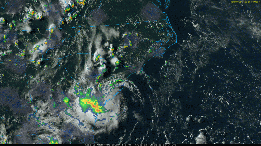
By WeatherFlow meteorologist Shea Gibson on 6/28/21. Well the NHC did name Invest 96L to TD4, and ultimately into Tropical Storm Danny this afternoon just ahead of landfall. They also mentioned one of our weather stations along the southern end of Folly Beach for reference in their decision-making processes along with hurricane reconnaissance. And 47mph…
By WeatherFlow meteorologist Shea Gibson on 6/27/21. This year we are already seeing some earlier-than-normal activity in areas where it would occur later in the hurricane season. Here is a prime example of a tropical wave approach that would usually occur in late July or possibly early August and through September/October. 6/27/21 Sunday 12:30PM ET…
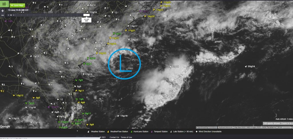
13 June 2021 – As we head into out 2021 hurricane season, we are seeing a couple of area of interest. One is in the Bay of Campeche and is expected to be very slow to aggregate over the coming days; however, the NHC (as of 2PM ET today) gives it a 30% chance to…