Forecast for Monday, Sept 20, 2024
Heat in the Central Valley is critical in producing the San Francisco Bay Area winds. That heat in the valley creates the low-pressure that produces the pressure gradient that sucks cool ocean winds through gaps in the Coast Range and over our launch sites.
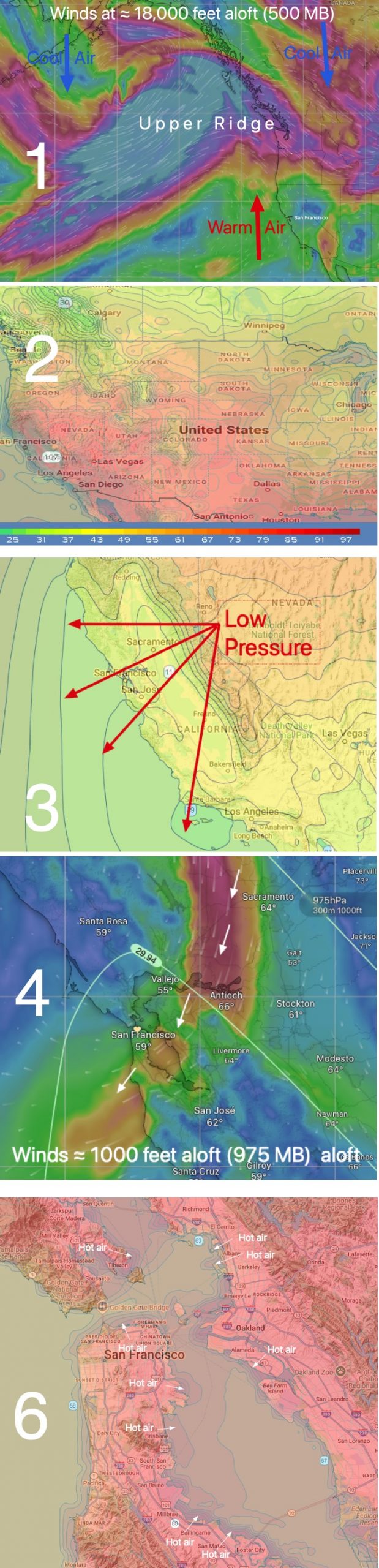
But too much heat can cause that Central Valley low-pressure to balloon over the coast creating a weak winds scenario. This imagery and forecast show how this happens:
Heat and much weaker winds that struggle to reach the shore. Usable winds OUTSIDE at a few sites.
Major reduction in the wind strength, especially near shore, at all sites except for a brief spike late at the Stick and OUTSIDE at Coyote and 3rd. This abrupt wind fade occurs as:
1. An upper level ridge at ≈ 18,000 feet aloft (500 MB) moves over the west coast.
2. This high-pressure dumps hot air over California, creating Heat Advisory conditions even near the coast and crushing the marine layer clouds.
3. This heat causes the Central Valley low-pressure to expand far over the coast weakening the pressure gradient.
4. That low-pressure causes NNE winds aloft blowing the NW ocean winds away from our coast and bringing hot air into the Bay Area.
5. Late in the day, the low-pressure retreats inland to about the East Bay shore.
6. The resulting weak pressure gradient brings mid to upper-teens winds to the middle of the Bay but Heat Bubbles expanding from the hot land keeps most of the water far from shore.