 We all know that San Francisco Bay Area forecasts are sometimes wrong. So all of you have learned to look for obvious hints that forecast has gone bad before you make the long drive. The most obvious hint is to look at how your site’s sensor and nearby sensors are ramping up. But that only helps you when it is just about time to make your drive to the launch site.
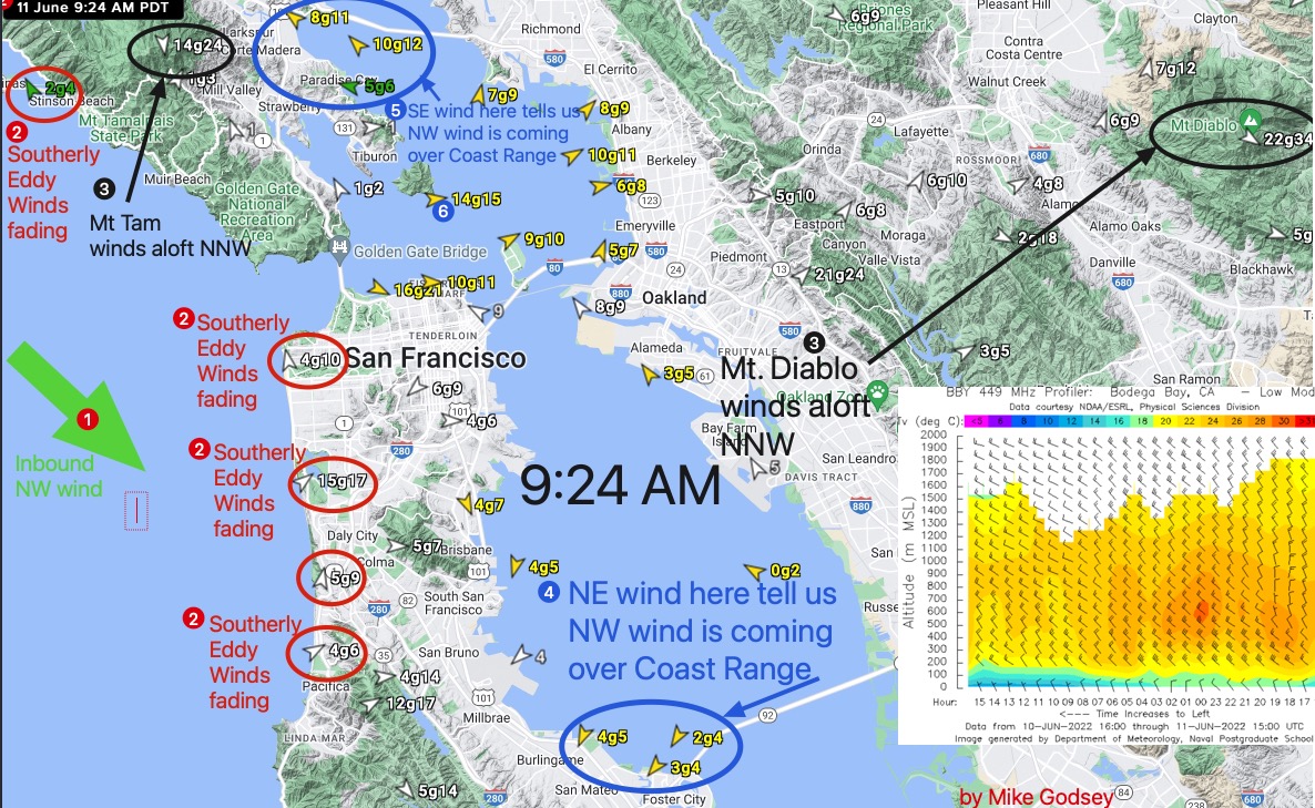
The image below from 9:24 AM today shows a few of the early signs to watch for mid-morning to tell if the forecast for afternoon winds is on track even before the winds develop at your launch site.
To start look at this graphic and find the following numbered circles.
1. First check out the ocean buoys’ wind strength. The stronger those winds the better the Crissy to Waddell winds.
2. Check if there are eddy southerly winds. If they are strong, building and holding S. the better the north tower, Pt. Isabel and Berkeley winds and the worse the 3rd. Ave winds inside. If the eddy winds are weak, fading and turning WNW the better the 3rd. Ave. winds INSIDE and the worse the winds at the other sites above. Today the eddy is weakening.

3. How strong and in what direction are the Mt. Tam and Mt. Diablo winds. If they are strong and have turned from NNE to NNW or NW then expect strong gusty winds from Anita Rock south to Waddell and unreliable winds for Pt. Isabel and Berkeley. Today those winds are turning NW.
4. Check if there are morning NE winds near 3rd. Ave. This indicates that NW winds aloft are descending the coast range, heating and creating a very local brief pressure gradient. This is a good sign for NW to WNW winds later at 3rd. Ave. unless there is lots of fog in the Hwy. 92 Gap.
5. Check the sensors in the Larkspur area. If they are SW to SSW expect good wind at Larkspur and/or Pt. Isabel. If the winds are SE it means that strong NW winds are moving over the coast range, warming and creating a brief local pressure gradient. This is a BAD sign for Pt. Isabel suggesting a fade and a good sign for later WNW winds for Rod & Gun.
6. The Blunt Point sensor is a good way of seeing how much wind energy is moving into the Bay Area. A strong reading here is good news for every site. Today shows lots of promise given that 14G15 reading as early as 9:24 AM.
And to get really geeky look at the Bodega profiler to see how the winds just aloft are changing. The most recent wind reading aloft is on the left side. Notice how the winds at 300 meters are already NW at 20 knots. And look how strong those winds aloft were yesterday by late afternoon. Given that the forecast is pretty similar it looks we may see those strong winds just aloft again today. And with the complex topography most sites have to the NW it is a good chance that turbulence will transfer some momentum to the surface winds.
Let’s see how all this plays out today.
