 Where does the heat come from and
why does it end with a blow.
by Mike Godsey, mike AT iwindsurf.com
So I was at Stevenson late yesterday afternoon waiting for the faint east winds to turn to cooling mild west winds enjoying the shade, great food and drink when I realized I had a blog topic. My 2 favorite retreats during the heat wave or two before a heat wave breaks are high mountain meadows or Stevenson. Why Stevenson? Because of the “heat bubble”.
You know the drill. A heat wave develops and the usually the Gorge winds come to a halt. Then you see cool places or cool drinks for a few days then Jones Beach blows and the next day the corridor sees wind. But those with enough cerebral cortex to cover an orange have to wonder why this happens.
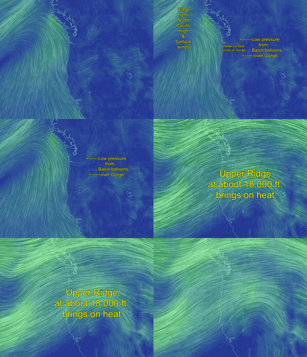
Let’s study the animation above for some answers. The animation starts at the surface. Note that there a strong North Pacific High west of the Gorge. This is a key ingredient for strong Gorge winds. But looking at the Gorge in the animation or at yesterday’s wind graphs you can see we have only weak surface winds.
You can also see that the thermal low pressure and heat in the Columbia Basin has ballooned westward over the Gorge. This destroys the pressure gradient isobar pileup between the North Pacific High and the Basin. Hence weak winds.
Now look at the second part of the animation. See the northward extending loop in the upper level winds at the 500 mb. level at ≈ 18,000 ft.? The air in this loop is a region of upper level high pressure. Looking carefully you can see the winds in this zone converging. As these winds converge the air piles up above us. This creates a high pressure and that air is forced downward in a process called subsidence. Think of this as the air way above us falling towards the surface.
As this happens the air compresses. As you have noticed when you pump up air into your bicycle compressing air creates heat. This descending air also stops the formation of clouds hence the severe blue skies. It also traps natural and human made pollutants hence the sometimes brownish tint to the air. Since the Basin has very low humidity it heats up faster than the surrounding mountains.
All this heat in the Basin causes the air there to expand creating an area of surface low pressure or thermal trough (aka “heat bubble”) . That expanding air has to go somewhere and it can not go up due to the aforementioned subsidence. So it expands into the Gorge bringing more heat and spoiling the pressure gradient.
So let’s see how all of this will impact the wind today Saturday Aug. 13, 2016.
Look at the isobars at 5AM this morning. Note the complete lack of isobars over the corridor. Looking at towards the Basin note the large ring of isobars. This is an area of low pressure. Note the isobar line near The Dalles.
Then at 11AM note that the North Pacific High has pushed a few isobars eastward towards Portland. At the same time the Basin is heating so the low pressure isobars have pushed westward. At this point there should be enough of a pressure gradient over the Jones Beach area for the wind to begin building there.
Now at 2 PM. If Crysta’s forecast is right, the isobars of the NPH and Columbia Basin low should begin to merge creating a weak pressure gradient over the corridor and the Hatch should see faint but building winds.
Then by 5PM the low pressure in the Basin retreats a bit more allowing the isobars of the NPH to expand fully into the corridor. So the winds reach at least the upper teens.
Typically the upper level high pressure you saw in the first image will move past us in a day or two. Then the heat bubble bursts as the Basin really contracts to its home location and the pressure gradient in the corridor and near east suddenly goes up as the isobars of the NPH compact over the Gorge and the pressure gradient to the Basin skyrockets.
All of this looks very simple in these diagrams since we are looking at a low resolution model. The last image gives you a hint of the real complexity.
We are left with the question of why the first day a heat wave fully ends the winds are so crazy gusty. Stay tuned for a future blog.

