Hello Weather Fans. Even though the winds are forecasted to be light to gentle, all of a sudden there is a strong gust of wind changing direction and speed. In this blog, let’s explore why wind speed and direction may change.
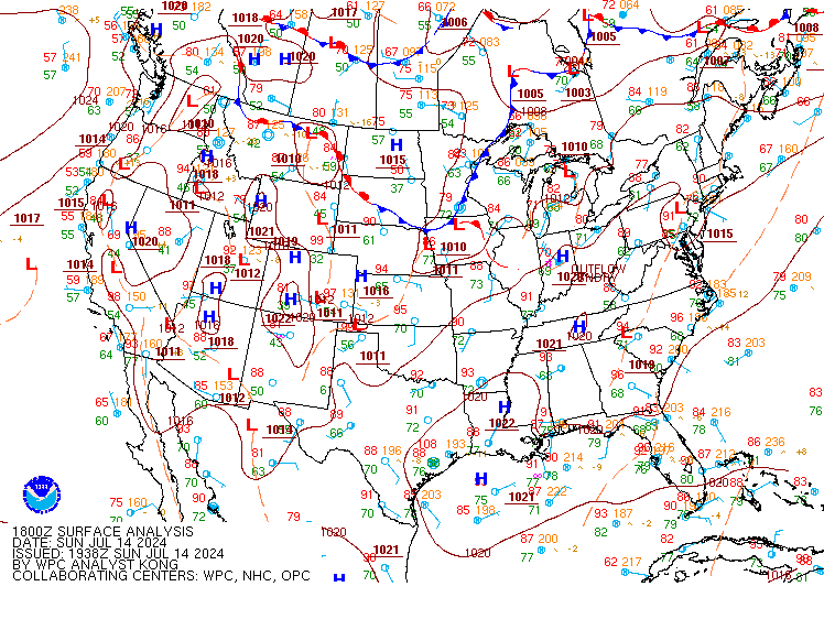
In the Chesapeake Region, on July 14th, 2024, a cell of thunderstorms developed, leading to an increase in wind speed. Even on a nice sunny day, clouds and storms can form, creating a change in the weather. Below, we have a surface analysis taken at 18z (2:00 PM). This chart shows us the fronts, wind direction, and temperature. East of the Appalachian Mountains, a shortwave trough extends north to south, from Maine to Virginia. A shortwave trough is a disturbance in the middle of the atmosphere that can provide lift to an area and help mix cold and warm air to generate storms.
Why do afternoon storms occur?
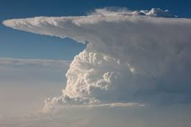
The sun heats the surface of the Earth as soon as it rises in the morning. The Earth’s surface and other materials like buildings retain and accumulate this heat throughout the day. Now, there are these molecules called thermals that want to rise to an area where it’s warmer than their environment. As the thermals rise, they cool and expand due to bumping into each other, creating space and becoming less dense. Finally, they reach a point where their relative humidity reaches the point of saturation, and they condense into a cloud.
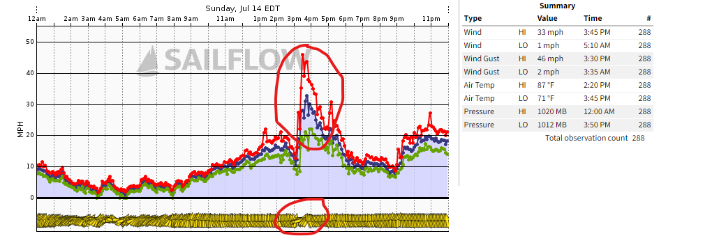
This is an image of what a Weather Pro Net station located at Tolly Point captured. To the right, you can see the recorded observations gathered in real-time. As you can see in the areas circled, winds spiked around 3:30 PM EDT with a gust in the mid-40s. Notice the second circle at the bottom: wind direction was initially a southerly flow, then shifted to a westerly flow.
This is what we call an outflow boundary. The leading edge of a thunderstorm separates cooler air from warmer air, similar to a front, and is followed by rain. Notice in the summary section to the right that both air pressure and temperature decreased at 3:45 PM EDT.
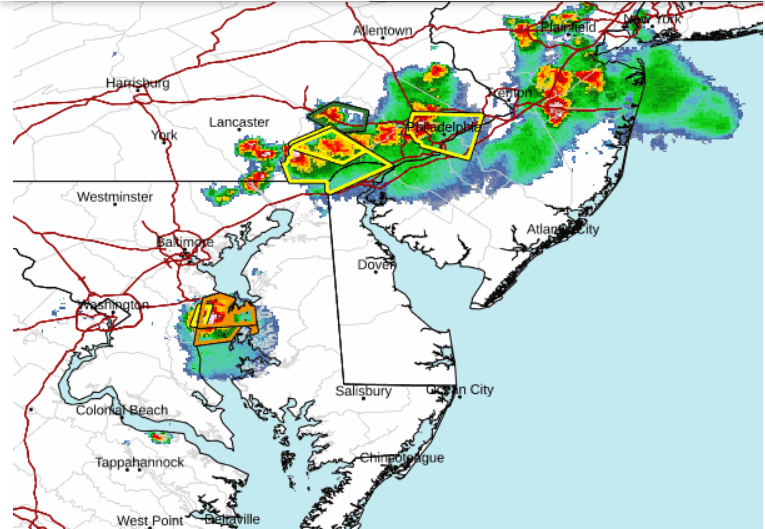
This is a radar image from the NWS service showing a line of thunderstorms stretching from New Jersey down to the Chesapeake, moving SE-ESE. Afternoon storms like this are called popcorn storms. They are usually brief but can still pose a threat. These types of popcorn cells typically begin due to daytime heating. Even though there was a shortwave disturbance just west of the Chesapeake region, this storm system developed due to a natural lifting process. Strong updrafts, also known as “free convection,” occur when air is buoyant. As we discussed earlier, warm air rises, expands, and cools.
Key Concepts and What to Look Out For:
- The sun’s solar radiation heats the Earth.
- Warm air rises, cools, and expands.
- Look for darker clouds.
- Temperature decreases.
- Wind speed and direction change.
- Even flying insects head inside.
- Lastly, you feel a nice cool breeze of air heading towards you, then comes the rain.