Massive North Pacific High  brings NW winds to most of the California
coast
by Mike Godsey
Yep it is mid fall the time of fading winds on the California coast as the North Pacific High shrinks and moves southward away from the Golden State. The time of year when the days are shorter and the temperatures are cooler in the California interior. Late Oct. and especially early November is a time of falling pressure gradients and faint winds.
So on this last day of the 2015 Weatherflow human forecasts why am I forecasting powerful NW winds from most of the Bay Area and Southern California for tomorrow Monday Nov. 2! It is easy to toss around words like “unprecedented” these day but try this one on for size… this is the first time in 25 years I have forecast strong winds from the North Pacific High in the mid fall!
Sure we sometimes have post frontal NW winds in the winter. Those types of brief NW winds occur everywhere in the N. hemisphere after the passage of a cold front. But tomorrows NW winds are coming from a 1800 miles in diameter North Pacific High and that is extremely unusual in mid fall.
Basically in recent years the oceans, especially the Pacific, have been storing excessive heat. This is why most of the west from Canada to Baja had such a mild winter in 2014/15.
So what was the proximal cause of all this ocean warming? In the north pacific much of it
came indirectly from what meteorologist called the RRR, the Ridiculously Resistant Ridge, which held position at ≈ 18,000 ft. over the eastern pacific and western North America much of the winter. This upper ridge shunted most of the storms  way north over the west coast while keeping warmer air at the surface. Hence record low snowfalls and warmer temps.
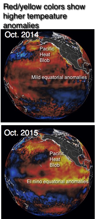
And out in the north pacific fewer storm means the there was little winter mixing of summer warmed surface waters with cooler waters from the depths. This gave rise to the Pacific Heat Blob you see in the very top image.
The Pacific Heat Blob meant unprecedented warm ocean waters for much of the west coast.
And less snow runoff meant unusually warm river waters in the Gorge and major salmon and sturgeon die offs.
The formation of such extremes in the upper level flows like the 2014/15 Ridiculously Resistant Ridge and the long lived 2014/15 upper troughs from the polar vortex that brought crazy cold temps to the east coast have long been predicted to increase by the climate models.
Likewise the abundance of east pacific hurricanes and the amazingly fast build up of Patricia, the strongest east pacific hurricane in history, was based upon this pacific warm up.
Looking at the 2015 image you can see that the major El Nino building fast the pacific is warming even more.
 So getting back to topic… the heat in the north pacific and the prolonged hurricane season have both help cause the North Pacific High to maintain its size and strength way into fall. But this time of year lots of storm systems swing towards the west coast and so far there is nothing like the RRR to divert them.
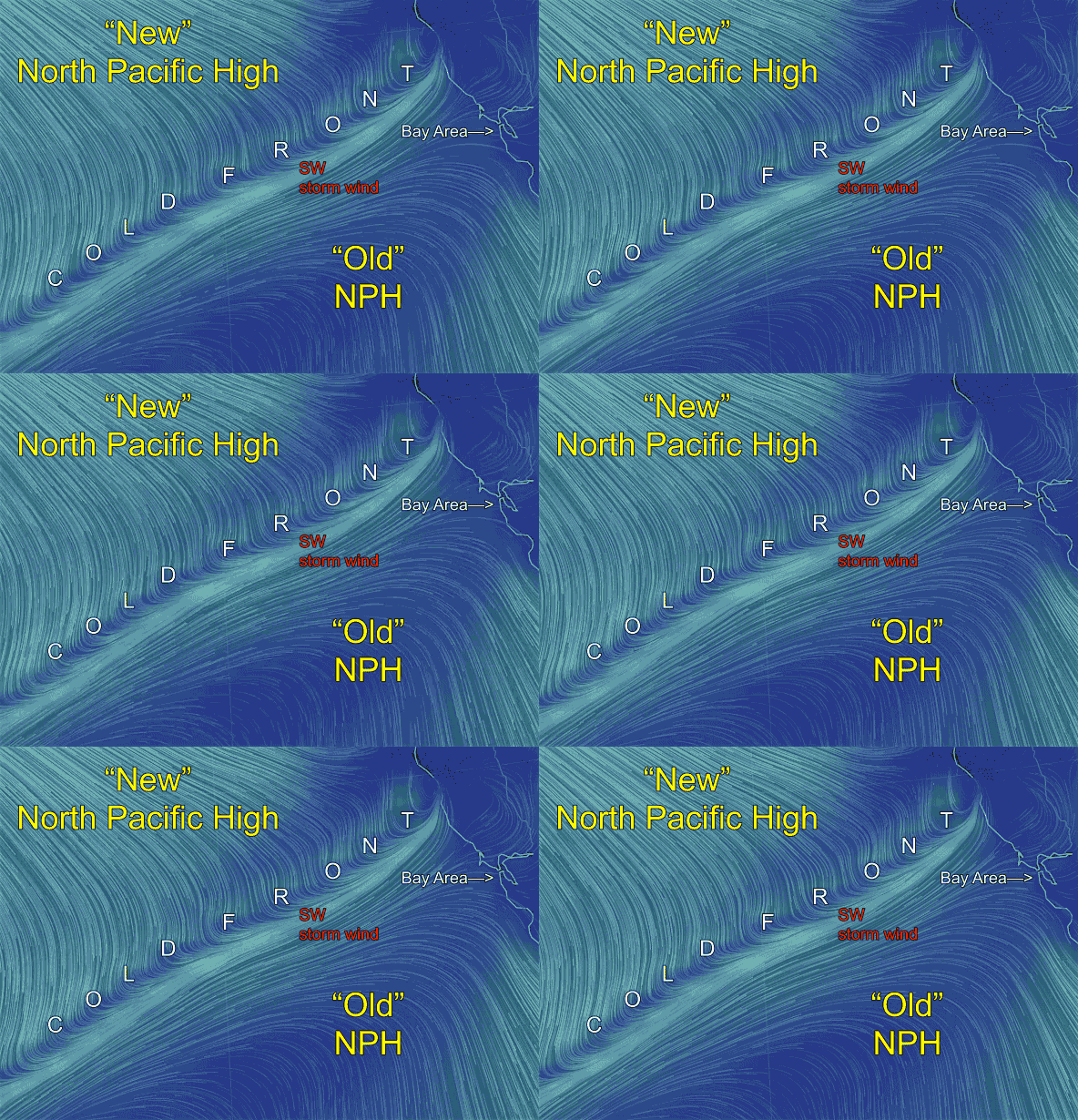
So today the Gorge is getting hit by rain and SW winds while Northern California has an approaching rainy cold front. You can see the cold front in the first animation I have annotated from nullshool.
Note how the weak NW winds of the old NPH have dropped south of the Bay Area. Then find the cold front approaching from the NW. Note the SW relatively warm storm wind. In the area of the cold front there will be rain that should graze parts of the Bay Area. Behind the cold front is what is called post frontal NW winds which we sometimes see after storms in the winter.
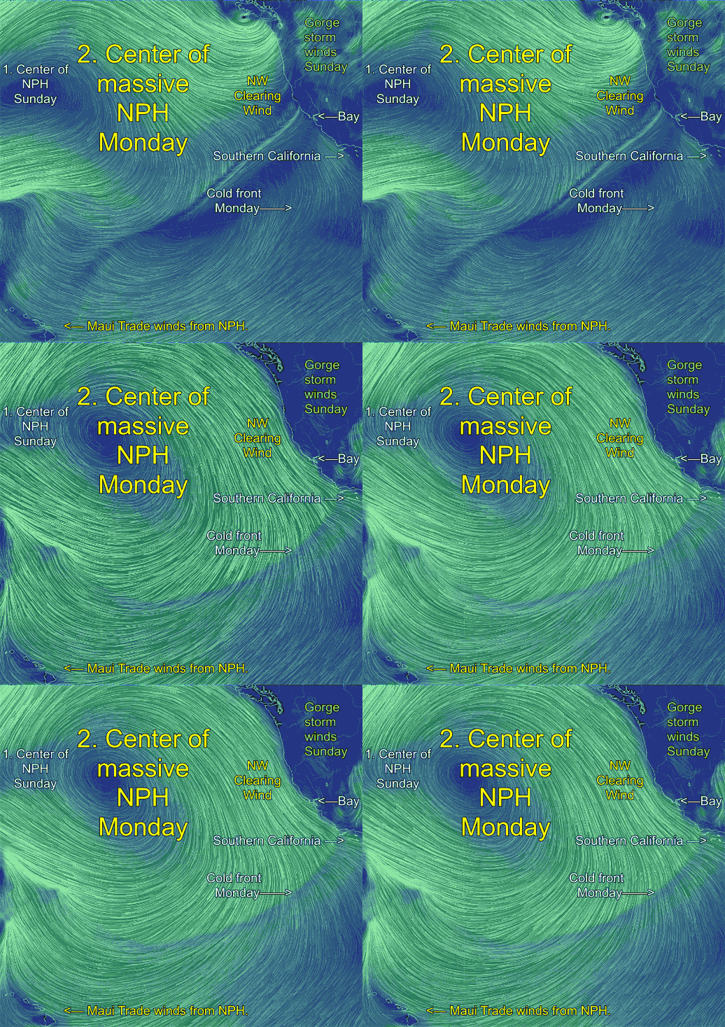
Behind this narrow zone of post frontal NW winds is a massive NPH that spans the waters from Maui to Alaska to California to Baja. And the portion of the North Pacific High near California will create strong NW clearing winds Monday. And aloft will be strong NNW winds that could interfere with the surface NW winds.
The challenge will be to get these ocean winds into the Bay and into the Southern California beaches. Both venues have largely lost the pressure gradient to the Central Valley for the Bay Area and the inland valleys and Southern California deserts for Southern California.
However I am seeing hints of a strong pressure gradient to the Great Basin which typically sucks those NW ocean winds inland. This usually means very gusty winds and kiters should use caution.
Shea Gibson, one of our east coast meteorologist, just reminded me that since tomorrows winds are partially post frontal NW winds and partially large scale NW winds from the NPH we will also see the effect of cold air advection that should jazz up the wind a bit. See Shea’s recent blog on this phenomenon:

